Neapolis, Ohio
Jump to navigation
Jump to search
Neapolis, Ohio | |
|---|---|
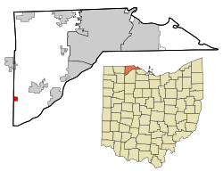
 Location in Lucas County and the state of Ohio. | |
| Coordinates: 41°29′26″N 83°52′36″W / 41.49056°N 83.87667°W | |
| Country | United States |
| State | Ohio |
| County | Lucas |
| Township | Providence |
| Area | |
| • Total | 0.71 sq mi (1.84 km2) |
| • Land | 0.71 sq mi (1.84 km2) |
| • Water | 0.00 sq mi (0.00 km2) |
| Elevation | 673 ft (205 m) |
| Population (2020) | |
| • Total | 497 |
| • Density | 700.00/sq mi (270.39/km2) |
| Time zone | UTC-5 (Eastern (EST)) |
| • Summer (DST) | UTC-4 (EDT) |
| ZIP codes | 43547 |
| FIPS code | 39-53718 |
| GNIS feature ID | 2628936[2] |
Neapolis is a census-designated place (CDP) in northwestern Providence Township, Lucas County, Ohio, United States.[2] As of the 2020 census it had a population of 497. It has a post office, with the ZIP code of 43547.[3]
History
Neapolis was laid out in 1872.[4] The community was named after Neapolis, in Ancient Greece.[5] A post office called Neapolis has been in operation since 1873.[6]
Demographics
| Census | Pop. | Note | %± |
|---|---|---|---|
| 2020 | 497 | — | |
| U.S. Decennial Census[7] | |||
References
- ^ "ArcGIS REST Services Directory". United States Census Bureau. Retrieved September 20, 2022.
- ^ a b c U.S. Geological Survey Geographic Names Information System: Neapolis, Ohio
- ^ Zip Code Lookup
- ^ Scribner, Harvey (1910). Memoirs of Lucas County and the City of Toledo: From the Earliest Historical Times Down to the Present, Including a Genealogical and Biographical Record of Representative Families. Western Historical Association. p. 172.
- ^ "Today's answer to cranium cracker". Times Daily. Mar 11, 1939. p. 5. Retrieved 6 October 2015.
- ^ "Lucas County". Jim Forte Postal History. Retrieved 6 October 2015.
- ^ "Census of Population and Housing". Census.gov. Retrieved June 4, 2016.
