Mystic Falls
Jump to navigation
Jump to search
| Mystic Falls | |
|---|---|
 Mystic Falls | |
 | |
| Location | Yellowstone National Park, Teton County, Wyoming |
| Coordinates | 44°29′03″N 110°52′26″W / 44.48417°N 110.87389°W[1] |
| Type | Cascade |
| Total height | 70 feet (21 m) |
| Watercourse | Little Firehole River |
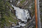
Mystic Falls is a 70-foot (21 m) cascade type waterfall on the Little Firehole River, a tributary of the Firehole River. Originally named Little Firehole Falls by members of the 1872 Hayden Geologic Survey, the name was changed to Mystic Falls by members of the Arnold Hague Geological Survey in 1885 for unknown reasons.[2] Mystic Falls is reached via the 1.2 miles (1.9 km) Mystic Falls Trail which starts at Biscuit Basin in the Upper Geyser Basin.
Gallery
-
 Spring runoff, June 2011

See also
References
- ^ "Mystic Falls". Geographic Names Information System. United States Geological Survey, United States Department of the Interior.
- ^ Whittlesey, Lee (1996). Yellowstone Place Names. Wonderland Publishing Company Gardiner, MT. p. 185. ISBN 1-59971-716-6.
External links
 Media related to Mystic Falls at Wikimedia Commons
Yellowstone National Park - Upper Geyser Basin | ||
|---|---|---|
Geothermal features and other attractions in the Upper Geyser Basin | ||
| Geysers |
|  |
| Hot springs | ||
| Structures and history | ||
| Geography | ||
| ||
| Authority control databases: Geographic |
|---|
This Wyoming-related article is a stub. You can help Wikipedia by expanding it. |
Categories:
- Articles with short description
- Short description is different from Wikidata
- Infobox mapframe without OSM relation ID on Wikidata
- Coordinates on Wikidata
- Commons category link from Wikidata
- Articles with World Waterfall identifiers
- Waterfalls of Yellowstone National Park
- Waterfalls of Teton County, Wyoming
- All stub articles
- Wyoming stubs
- Pages using the Kartographer extension