Mutawintji National Park
| Mutawintji National Park New South Wales | |
|---|---|
 Aboriginal rock art located within the national park, 1976. | |
 Mutawintji National Park | |
| Nearest town or city | White Cliffs |
| Coordinates | 31°08′48″S 142°22′53″E / 31.14667°S 142.38139°E |
| Established | 4 September 1998[1] |
| Area | 689.12 km2 (266.1 sq mi)[1] |
| Managing authorities | NSW National Parks & Wildlife Service |
| Website | Mutawintji National Park |
| See also | Protected areas of New South Wales |
The Mutawintji National Park, formerly the Mootwingee National Park, is a protected national park that is located in the Far West region of New South Wales, in eastern Australia. The 68,912-hectare (170,290-acre) national park is situated approximately 880 kilometres (550 mi) west of Sydney and about 130 kilometres (81 mi) north-east of Broken Hill.
Features and location

The rugged, mulga-clad Byngnano Range is dissected by colourful gorges, rockpools and creek beds lined with red gums. Scattered among the caves and overhangs are Aboriginal rock art and engravings.
In 1979, the Foundation for National Parks & Wildlife purchased and fenced 100 square kilometres (39 sq mi), in the Coturaundee Ranges, now part of Mutawintji National Park, for the conservation and protection of the yellow-footed rock wallaby.
Follow-up funding of fox eradication in the reserve ensured the survival of this last population of yellow-footed rock-wallabies in New South Wales. Of the wild animals, wedge-tailed eagle, peregrine falcon, short-billed correllas, zebra finches, budgerigars, apostle birds and magpies can also be found here.[2]
The park also protects Mutawintji Historic Site, containing one of the best collections of Australian Aboriginal rock art.[3]
See also
References
- ^ a b "Mutawintji National Park: Park management". Office of Environment & Heritage. Government of New South Wales. Retrieved 12 October 2014.
- ^ "Mutawintji National Park | Learn more". NSW National Parks. Retrieved 18 November 2021.
- ^ "Mutawintji Historic Site". NSW National Parks & Wildlife Service. Government of New South Wales. Retrieved 12 October 2014.
Gallery
-
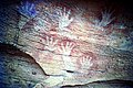 Hand stencils. Mootwingee.
 -
 Etched rock figures. Mutawintji National Park
 -
 Waterhole, Mootwingee
 -
 Rock etchings. Mootwingee
 -
 Hand stencils in rock overhang, Mootwingee
 -
 Mootwingee waterhole
 -
 Ancient rock etchings. Mootwinjee
 -
 Etched human-like figures. Mootwingee
 -
 Kangaroos etched on rocks. Mootwingee


External links
- "Mutawintji Lands: Plan of management" (PDF). NSW National Parks & Wildlife Service (PDF). Government of New South Wales. 2013. ISBN 978-1-74359-284-7.
- Mutawintji National Park (PDF) (PDF Map). NSW National Parks & Wildlife Service, Government of New South Wales.
- The Archaeology of Mootwingee,Western New South Wales by F. D. McCarthy and N. W. G. Macintosh. Records of the Australian Museum, VOL. XXV, No. 13, 1962, pp. 249–298.
This New South Wales protected areas related article is a stub. You can help Wikipedia by expanding it. |
- Use dmy dates from August 2021
- Use Australian English from September 2011
- All Wikipedia articles written in Australian English
- Articles with short description
- Short description is different from Wikidata
- IUCN Category II
- Coordinates on Wikidata
- Commons category link from Wikidata
- National parks of New South Wales
- Protected areas established in 1998
- Rock art in Australia
- 1998 establishments in Australia
- Far West (New South Wales)
- All stub articles
- New South Wales protected area stubs