Murodō
Jump to navigation
Jump to search

Murodō (室堂, Muro-do, IPA: [Murodo]) is a volcanic plateau located near Tateyama in Toyama Prefecture, central Honshu, in Japan.
Murodō is located on the Tateyama Kurobe Alpine Route. Murodō's is located near Mount Tate, Mount Tsurugi and other peaks. Murodō is the highest point on the Tateyama Kurobe Alpine Route, reaching 2,450 meters (8,038 feet) above sea level.[1]
Geography
Murodō was formed from maar. The Mikuriga-ike pond and the Midoriga-ike pond are near Murodō station.
Gallery
-
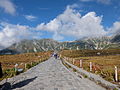 The trail from Murodo St. to Murodo plateau
 -
 Mikuriga-ike pond
 -
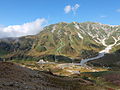
 Jigokudani seen from Murodo
 -
 The trail from Murodo plateau to Raityo-so (Hotel)
 -
 Raityozawa Camp Site
 -
 Midoriga-ike pond
 -
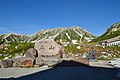 Murodo St. near by the stone monument.


See also
References
- ^ "Murodo - The Highest Point on the Alpine Road". www.kanpai-japan.com. Retrieved 2023-10-21.
Categories:
- Articles with short description
- Short description matches Wikidata
- Articles containing Japanese-language text
- Pages with Japanese IPA
- Toyama Prefecture articles missing geocoordinate data
- All articles needing coordinates
- Articles missing coordinates with coordinates on Wikidata
- Wetlands of Japan
- Ramsar sites in Japan
- Landforms of Toyama Prefecture
- Tateyama, Toyama
- Chūbu-Sangaku National Park
- Tateyama Kurobe Alpine Route