Mungret
Jump to navigation
Jump to search
Mungret
Mungairit | |
|---|---|
Village | |
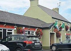
 Pub and restaurant in Mungret | |
| Coordinates: 52°38′08″N 8°41′34″W / 52.6356°N 8.6928°W | |
| Country | Ireland |
| Province | Munster |
| County | County Limerick |
| Population | 277 |
| Irish grid reference | R530540 |
Mungret (Irish: Mungairit)[2] is a village and civil parish in County Limerick, Ireland. It is located close to Limerick City on the N69 national secondary road. As of the 2016 census, the village had a population of 277 people.[1]
The local church, which is dedicated to Saint Oliver Plunkett, was built in 1981; and is in the parish of Mungret, Crecora and Raheen within the Roman Catholic Diocese of Limerick.[3] The local Gaelic Athletic Association club is Mungret St. Pauls GAA.[4]
Places of interest
Mungret Abbey, approximately 1 kilometre (0.62 mi) east of the village, is a medieval friary and designated National Monument within the parish.[5]
Close to the abbey is Mungret College, a (former) Jesuit secondary school.
See also
References
- ^ a b "Sapmap Area - Settlements - Mungret". Census 2016. Central Statistics Office. April 2016. Retrieved 27 December 2020.
- ^ "Mungairit / Mungret". logainm.ie. Irish Placenames Commission. Retrieved 27 December 2020.
- ^ "Mungret Church". mcrparish.com. Parish of Mungret, Crecora & Raheen. Retrieved 27 December 2020.
- ^ "Mungret St Pauls History". mungretstpauls.com. Retrieved 27 December 2020.
- ^ "Mungret Parish History". mcrparish.com. Parish of Mungret, Crecora & Raheen. Retrieved 27 December 2020.
Categories:
- Articles with short description
- Short description is different from Wikidata
- Use dmy dates from December 2021
- Use Hiberno-English from December 2021
- All Wikipedia articles written in Hiberno-English
- Articles containing Irish-language text
- Coordinates on Wikidata
- Articles with OS grid coordinates
- Untranslated Irish place names
- Towns and villages in County Limerick
- Civil parishes of County Limerick

