Mt. McSauba Site
Jump to navigation
Jump to search
Mt. McSauba Site | |
 | |
  | |
| Location | Near Mt. McSauba, north of Charlevoix, Michigan[2] |
|---|---|
| Coordinates | 45°20′10.018″N 85°14′49.754″W / 45.33611611°N 85.24715389°W |
| Area | 5 acres (2.0 ha) |
| NRHP reference No. | 76001025[1] |
| Added to NRHP | September 29, 1976 |
The Mt. McSauba Site, also designated 20CX23, is an archaeological site located near Charlevoix, Michigan. It was listed on the National Register of Historic Places in 1976.[1] The site is an encampment on a dune.[3]
Gallery
-
 Description of Chief McSauba
 -
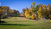 Ski Area on Mt. McSauba


References
- ^ a b "National Register Information System". National Register of Historic Places. National Park Service. July 9, 2010.
- ^ The NRIS lists the Mt. McSauba Site as "Address Restricted." However, references place it at Mt. McSauba. Geo-coordinates are approximate.
- ^ William A. Lovis; G. William Monaghan; Alan F. Arbogast; Steven L. Forman (2012), "Differential temporal and spatial preservation of archaeological sites in a great lakes coastal zone", American Antiquity: 591–608
| Topics | |
|---|---|
| Lists by state |
|
| Lists by insular areas | |
| Lists by associated state | |
| Other areas | |
| Related | |
This article about a property in Michigan on the National Register of Historic Places is a stub. You can help Wikipedia by expanding it. |
Categories:
- Pages using gadget WikiMiniAtlas
- Articles using NRISref without a reference number
- Articles with short description
- Short description matches Wikidata
- Use mdy dates from August 2023
- Short description is different from Wikidata
- Coordinates on Wikidata
- National Register of Historic Places in Charlevoix County, Michigan
- Archaeological sites in Michigan
- Archaeological sites on the National Register of Historic Places in Michigan
- All stub articles
- Michigan Registered Historic Place stubs