Mount Nagamine
Jump to navigation
Jump to search
| Mount Nagamine | |
|---|---|
| 長峰山 | |
 Mount Nagamine from Kobe University | |
| Highest point | |
| Elevation | 687.8 m (2,257 ft) |
| Listing | List of mountains and hills of Japan by height |
| Coordinates | 34°44′21″N 135°13′5″E / 34.73917°N 135.21806°E |
| Naming | |
| English translation | Long ridge Mountain |
| Language of name | Japanese |
| Pronunciation | [neɡaminesaɴ] |
| Geography | |
| Location | Nada, Kobe, Hyogo, Japan |
| Parent range | Rokko Mountains |
Mount Nagamine (長峰山, Nagamine-san) is a 687.8 m (2,257 ft) mountain in Nada, Kobe, Hyogo, Japan. This mountain is one of the major mountains of Rokko Mountains. Mount Nagamine literally means, long ridge mountain.
Outline
Mount Nagamine is on a ridge, which branches off a main ridge of Rokko Mountains. Because the ridge stretches to the south, toward the Osaka-Kobe metropolitan area, climbers can enjoy attractive views from the top. On the top of the mountain, there is a rock called ‘Tenguzuka’. This mountain belongs to the Setonaikai National Park.
Route
This mountain has major two routes to the top. One is from Hankyu Rokko Station, and the other is from Ōji-kōen Station. It takes one and half hours from these stations to the top.
Access
Gallery
-
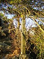
 Tenguiwa Rock on the top of Mount Nagamine (11/2008)
 -
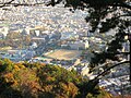
 A view at the top of Mount Nagamine (11/2008)
 -
 A view in the middle of Mount Nagamine (11/2008)
 -
 Mount Rokko from Mount Nagamine (11/2008)
 -
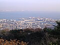
 Osaka metropolitan area from the top of Mount Nagamine (11/2008)
 -
 Rokko Island from the top of Mount Nagamine (11/2008)
 -
 Kobe University from the top of Mount Nagamine (11/2008)
 -
 A view on the way to Mount Nagamine (11/2008)


