Mount Kei Central Forest Reserve
| Mount Kei Central Forest Reserve | |
|---|---|
IUCN category VI (protected area with sustainable use of natural resources)[1] | |
| Nearest city | Koboko |
| Coordinates | 3°41′N 31°08′E / 3.683°N 31.133°E |
| Area | 384 sq.km |
| Governing body | National Forestry Authority |
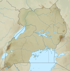
Mount Kei Central Forest Reserve is a protected area located in Koboko district, in the extreme north-west of Uganda. It covers an area of 384 square kilometers and is known for its diverse ecosystem consisting of dense savanna vegetation, forest, scrubland and a wide range of wildlife.[2]
Location and structure
Mt Kei Central Forest Reserve was formerly known as Mount Kei Rhino Sanctuary. It is also situated in the Sudan-Guinea Savanna biome. It borders Kaya river and the international border with Sudan in the north, river Kechi in the east. Its co-ordinates, latitude and longitude are N03.59134 and E31.09947, respectively. It receives mean Annual Rainfall of 1250 millimetres and mean Annual Temperature of 23 ∘ C.[3] This reserve has an elevation range of 915–1,330 m and is mainly classified into dry Combretum-Terminalia savanna and Butyrospermum savanna woodland. The National Forestry Authority(NFA) which is in charge of managing, demarcating, re-surveying and maintaining all Central Forest Reserves in Uganda.[4] The population around the reserve is sparse.
Flora and Fauna
The reserve can broadly be classified into dry Combretum-Terminalia savanna and Butyrospermum savanna woodland, scrubland and a wide range of wildlife. It also has 175 bird species, 54 moths species, 21 mammal species,126 butterflies species and 229 tree species.[2]
Activities and attractions
The region is largely undisturbed by human activities. Mount Kei Forest Reserve is mainly used as a source of firewood, honey, construction poles, medicinal plants and it also acts as a water catchment area. Another activity is the forest hikes which help in exploring the entire reserve.[5]
Challenges
The persistence war in South Sudan poses a great danger to such areas since its yields to a great number of refugees seeking for a place of relocation. Another threat are the wild fires and agriculture.[6]
References
- ^ Protected Area Profile for Mount Kei from the World Database on Protected Areas. Retrieved October 3, 2023.
- ^ a b Howard, P. C.; Davenport, T. R. B.; Kigenyi, F. W.; Viskanic, P.; Baltzer, M. C.; Dickinson, C. J.; Lwanga, J.; Matthews, R. A.; Mupada, E. (June 2000). "Protected Area Planning in the Tropics: Uganda's National System of Forest Nature Reserves". Conservation Biology. 14 (3): 858–875. doi:10.1046/j.1523-1739.2000.99180.x. ISSN 0888-8892. S2CID 84897191.
- ^ Kasangaki, Patrice; Akol, Anne M.; Basuta, Gilbert Isabirye (2012-08-09). "Butterfly Species List for Selected West Albertine Rift Forests". Dataset Papers in Science. 2013: e451461. doi:10.7167/2013/451461.
- ^ "NFA | National Forestry Authority - Mandated to manage all central forestry reserves by Government of Uganda". www.nfa.go.ug. Retrieved 2023-06-15.
- ^ "Best Hiking Trails in Mt. Kei Central Forest Reserve". GaiaGPS.com. Retrieved 2023-06-15.
- ^ "Mount Kei Forest Reserve, Uganda - KeyBiodiversityAreas.org". www.keybiodiversityareas.org. Retrieved 2023-06-15.
