Mount Hyōno
Jump to navigation
Jump to search
| Mount Hyōno | |
|---|---|
| 氷ノ山 | |
 A View of Mt. Hyōno | |
| Highest point | |
| Elevation | 1,509.6 m (4,953 ft) |
| Listing | Mountains of Japan |
| Coordinates | 35°21′14″N 134°30′49″E / 35.35389°N 134.51361°E |
| Naming | |
| Language of name | Japanese |
| Pronunciation | [çjoːnoseɴ] |
| Geography | |
| Country | Japan |
| Prefectures | Hyōgo and Tottori |
| City/Town | Yabu and Wakasa |
| Parent range | Chūgoku Mountains |
| Geology | |
| Mountain type | Upheaved submarine volcano |


Mount Hyōno (氷ノ山, Hyō-no-sen) is a mountain on the border of Yabu, Hyōgo Prefecture, and Wakasa, Tottori Prefecture, in Japan. It is the highest mountain in Hyōgo Prefecture. This mountain is one of the 200 famous mountains in Japan. Other names of this mountain are Suga-no-sen, Hyō-zan, Hyō-no-yama, Kōri-no-yama.
Outline
Mount Hyōno is estimated as an upheaved submarine volcano which erupted three million years ago with Mount Naki and Torokawa-daira highland. This mountain is the second highest mountain in Chūgoku Mountains, and also the second highest in Honshū west of Osaka Prefecture. This mountain is in the Hyōnosen-Ushiroyama-Nagisan Quasi-National Park. This mountain is also selected as one of the 100 untrodden areas in Japan.
Access
- Fukusada Bus Stop of Zentan Bus.
Gallery
-
 Mount Hyōno from northeast
 -
 Mount Hyōno from north
 -
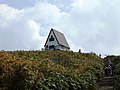
 A religious object in Mount Hyōno
 -
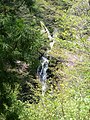 Fudo Waterfall in Mount Hyōno
 -
 A rock on the route to the top of Mount Hyōno from northMount Tanigawa from south
 -
 The top of Mount Hyōno from north
 -
 Southside view from the top of Mount Hyōno
 -
 The top of Mount Hyōno


See also
References
Categories:
- Pages using gadget WikiMiniAtlas
- Articles with short description
- Short description is different from Wikidata
- Coordinates on Wikidata
- Pages with Japanese IPA
- Pages using infobox mountain with language parameter
- Articles containing Japanese-language text
- Mountains of Hyōgo Prefecture
- Mountains of Tottori Prefecture
- Volcanoes of Tottori Prefecture