Mount Derak
Jump to navigation
Jump to search
This article has multiple issues. Please help improve it or discuss these issues on the talk page. (Learn how and when to remove these template messages)
|

| Mount Derock | |
|---|---|
 View of Drak Mountain located in Shiraz, Iran | |
| Highest point | |
| Elevation | 9,514 ft (2,900 m) |
| Prominence | 4,605 ft (1,404 m) |
| Coordinates | 29°41′02″N 52°24′14″E / 29.684°N 52.404°E |
| Geography | |
| Location | Shiraz, Iran |
| Parent range | Zagros Mountains |
| Topo map | Mount Derak |
| Geology | |
| Age of rock | < 40,000 yrs |
| Mountain type | Sedimentary rock |
| Climbing | |
| First ascent | 1841 |
| Easiest route | Hike via south western zone |
Mount Derock or Deraak (also known as Kuh-eh Barfee[1] or Mother Mount) is a sedimentary rock mountain in Shiraz, Fars, in the Middle East region in Iran. It is located west[2] and northwest of Shiraz, Fars. It is called mother mountain because its shape resembles a pregnant woman lying on her back and the name barfi mountain refers to it usually being white-capped in winter, barf meaning snow in Persian.[3]
Geologically, Shiraz is a syncline valley city (NW–SE elongated) that formed between the Baba Kohi and Derak anticlines.[4]
-
 Mount Derak view from Shiraz in winter
 -
 Snow Mount Derak
 -
 Mount Derak view from Shiraz in winter
 -
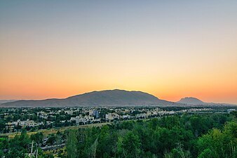
 Sunset in Shiraz viewing north-west – Kowsar hospital is visible in the bottom right
 -
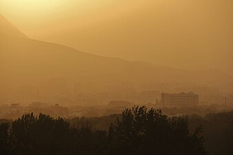
 Golden hour in Shiraz viewing Mt. Derak


References
- ^ Edmondson, John R.; Lack, H. Walter (2006). "Karl Georg Theodor Kotschy's itinerary in southern Iran, 1841–42" (PDF). Botanic Garden and Botanical Museum Berlin. 36: 579–588. doi:10.3372/wi.36.36154. S2CID 85095226.
- ^ Mobaraki, Abdollah (2012). Strategies for Mitigating Urban Heat Island Effects in Cities: Case of Shiraz City Center (PDF) (Thesis). Eastern Mediterranean University.
- ^ Foundation, Encyclopaedia Iranica. "Welcome to Encyclopaedia Iranica". iranicaonline.org. Retrieved 2021-05-04.
- ^ Torghabeh, Amir Karimian; Pradhan, Biswajeet; Jahandari, Ashkan (2020-05-01). "Assessment of geochemical and sedimentological characteristics of atmospheric dust in Shiraz, southwest Iran". Geoscience Frontiers. 11 (3): 783–792. doi:10.1016/j.gsf.2019.08.004. hdl:10453/139938. ISSN 1674-9871.
Categories:
- Pages using gadget WikiMiniAtlas
- Articles with short description
- Short description is different from Wikidata
- Articles needing additional references from January 2021
- All articles needing additional references
- Articles needing cleanup from September 2021
- All pages needing cleanup
- Articles with multiple maintenance issues
- Coordinates on Wikidata
- Mountains of Iran
- Landforms of Fars province
- Mountains of Fars Province