Moshoryne
This article includes a list of general references, but it lacks sufficient corresponding inline citations. (October 2023) |
Moshoryne
Мошорине | |
|---|---|
 | |
 Moshoryne  Moshoryne | |
| Coordinates: 48°42′49″N 32°40′24″E / 48.71361°N 32.67333°E | |
| Country | |
| Oblast | |
| Raion | |
| Founded | 1752 |
| Area | |
| • Total | 8,043 km2 (3,105 sq mi) |
| Population (2022) | |
| • Total | 1,600 |
| • Density | 0.20/km2 (0.52/sq mi) |
Moshoryne (Ukrainian: Мошорине) is a village in central Ukraine, Kropyvnytskyi Raion, Kirovohrad Oblast, in Subottsi rural hromada. It has a population of 1,600 (2022 estimate).[1]
Geography
The Beshka River flows through the territory of the village
History
The village was founded by Serbian immigrants in the middle of the 18th century, probably from the Serbian village of Moshoryn, and they named the local river Beshka, probably after the village of Beshka in Serbia, where the immigrants could have come from.

In 1772 there were 121 houses.
As of 1886 3359 people lived here. Here were 536 farm households, an Orthodox church, a school, and 9 benches.
During the Holodomor of 1932–1933, at least 26 villagers died. According to the recollections of a local resident, Olena Yermolenko (1913-2002): "Every day in 1933, on my way home from work, I saw people lying by the road from the collective farm, from which the Soviet soldiers took the last bread: adults, old people, children whose after a long period of starvation, the bellies swelled and cracked, and liquid flowed from the cracks. They suffered for several weeks, their bodies were secretly buried outside the village. Several hundred other families in Moshoryne, who had their own farms, were recognized by the government as "kurkuls" and were imprisoned or shot.".[2].
In 1943, during the battles of the World War II, according to the recollections of Olena Yermolenko (1913-2002), "cows stood in blood up to the level of their bellies" (the entire surrounding area was smeared with human blood) [3].
Gallery
-
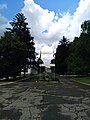
 a monument to the 250th anniversary of the village
 -
 administrative building
 -
 school
 -
 football field
 -
 memorial to Semen Klimovsky
 -
 central street
 -
 lane
lane -
 landscape
 -
 a bridge over the Beshka River
 -
 one of the wells
 -
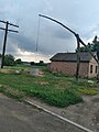
 abandoned yard
 -
 stork's nest


Notes
- ^ Чисельність наявного населення України на 1 січня 2022 [Number of Present Population of Ukraine, as of January 1, 2022] (PDF) (in Ukrainian and English). Kyiv: State Statistics Service of Ukraine. Archived (PDF) from the original on 4 July 2022.
- ^ Голодомор 1932-33 рр.: Знам'янський район – боротьба за життя
- ^ Воспоминания об освобождении Кировоградщины (материалы, статьи, рассказы). Издание отдела пропаганды и агитации Кировоградского обкома КП(б)У. 1945 г. (Публикация на сайте Областной Кировоградской универсальной научной библиотеки имени Чижевского.)
- Кількість наявного населення по кожному сільському населеному пункту, Кіровоградська область (осіб) - Регіон , Рік (2001(05.12)). database.ukrcensus.gov.ua. Банк даних Державної служби статистики України.
- Розподіл населення за рідною мовою, Кіровоградська область (у % до загальної чисельності населення) - Регіон, Рік , Вказали у якості рідної мову (2001(05.12)). database.ukrcensus.gov.ua. Банк даних Державної служби статистики України.
- CS1 uses Ukrainian-language script (uk)
- CS1 Ukrainian-language sources (uk)
- Articles with short description
- Short description is different from Wikidata
- Articles lacking in-text citations from October 2023
- All articles lacking in-text citations
- Coordinates on Wikidata
- Articles containing Ukrainian-language text
- Articles needing additional references from September 2023
- All articles needing additional references
- Villages in Kropyvnytskyi Raion
- 1752 establishments in Europe
- 18th-century establishments in Ukraine