Meppadi
Meppadi | |
|---|---|
Village | |
| Meppadi | |
.jpg) | |
 Meppadi | |
| Coordinates: 11°33′28″N 76°07′55″E / 11.55786°N 76.13199°E | |
| Country | India |
| State | Kerala |
| Government | |
| • Type | Panchayat Raj |
| • Body | Meppadi Grama Panchayat |
| Time zone | UTC+5:30 (IST) |


Meppadi is a village in the Indian state of Kerala. It is an extremely scenic hill station on the State Highway between Kozhikode and Ooty. The nearest city is Kalpetta, which is the headquarters of the Wayanad revenue district.
Economy
Tea cultivation is the main economic activity of Meppadi village. There are also some vegetable cultivation on small scale. Most of the people living in Meppadi are workers in various tea estates where they cultivate cardamom too. There is a small town catering to locals and the tourists. The tourists come to enjoy the salubrious climate of the place.[1]
Distance
Meppadi is 12 km from Kalpetta town in the Wayanad District. It is 78 km from Kozhikode (Calicut), 106 km from Ooty, and 281 km from Bangalore.[2]
Tourist attractions
- Kanthanpara Water falls
- 900 Kandi
- Soochipara Falls
- Meenmutty Falls, Wayanad
- Edakkal Caves
- Pookot Lake
- Chembra Peak
- Karapuzha Dam
- Vellarimala
- Sunrise valley
- Karapuzha Dam
- Thanhilode[3]
Image gallery
-
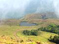 Chembra
 -
 Entering Soochippara
 -
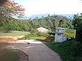
 Muster Office
 -
 St.Josephs School
 -
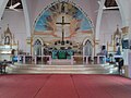 Inside the St.Joseph Church


See also
- Chundale town
- Kalpetta town
- Mango Orange village
- Vaduvanchal town
References
| History of Wayanad | |||||
|---|---|---|---|---|---|
| Cities | |||||
| Transport |
| ||||
| Education in Wayanad |
| ||||
| Visitor attractions | |||||
| Places of worship | |||||
| Other topics | |||||
11°34′N 76°09′E / 11.567°N 76.150°E
This article related to a location in Wayanad district, Kerala, India is a stub. You can help Wikipedia by expanding it. |
- All articles with dead external links
- Articles with dead external links from August 2022
- Use dmy dates from August 2018
- Use Indian English from August 2018
- All Wikipedia articles written in Indian English
- Articles with short description
- Short description is different from Wikidata
- Commons category link from Wikidata
- Coordinates on Wikidata
- Villages in Wayanad district
- Hill stations in Kerala
- Populated places in the Western Ghats
- Geography of Wayanad district
- All stub articles
- Wayanad district geography stubs