Mentone Beach
Mentone Beach | |
|---|---|
Beach | |
 Mentone Beach outside Life saving club | |
| Coordinates: 37°59′06″N 145°04′08″E / 37.98500°N 145.06889°E | |
| Location | Mentone, Victoria |
| Dimensions | |
| • Length | 1.6 km |
| Patrolled by | Mentone Lifesaving Club |
| Hazard rating | 3/10 (Moderately hazardous) |
| Access | Beach Road, Mentone |
Mentone Beach is a beach located in Mentone, on Port Phillip Bay, Victoria, Australia, 21 kilometres south from the Melbourne City Centre.[1] Mentone beach is the northern section of a beach that extends alongside Beaumaris Bay from the cliffs at Rickett's Point in Beaumaris to Frankston in the south on the eastern shoreline of Port Phillip Bay.
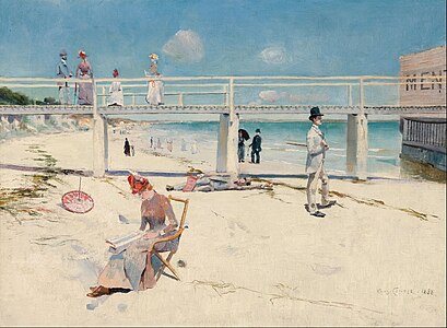
Mentone Beach is one of the Port Phillip Bay beaches associated with the Heidelberg School of Australian artists.[2]
Geology
Mentone Beach was formed when Port Phillip sunklands in southern Victoria were inundated to form Port Phillip Bay. The inundation was triggered in part by the Selwyn Fault on the east and the Rowsley Fault on the west side of the bay.[3] The Beaumaris Monocline is a geological feature which is expressed in the cliffs near Beaumaris and Rickett's Point at the northern end of Mentone Beach. This structure controls the coastal indentation, and therefore the Mentone and Mordialloc beaches, which lie due south of Rickett's Point. [4]
Seagull rock is a large rock in the shallow water off the beach. It is home to albatrosses, cormorants and seagulls.
OzCoast, the Geoscience Australia Online Coastal Information Database, describes[5] Mentone Beach as:
| Length (km) | 1.6 |
| Orientation (degree) | 210 |
| Embaymentisation [6] | 1.0 |
| Number of bars | 3 |
| Wave height (m) | 0.4 |
| Wave period (sec) | 5.0 |
| Tide station | Melbourne |
| Spring tide (m) | 0.8 |
| Neap tide (m) | 0.2 |
Aboriginal history
Prior to European settlement the area around Mentone Beach was the land of the Bunurong people of the Kulin nation. Between 1839 and 1849 the Bunurong people and the area around Mentone Beach came under the control of the Port Phillip Protectorate.[7]
European history
In the summer of 1886 and 1887 Tom Roberts and Frederick McCubbin who had formed the Heidelberg School of painting set up a painters camp at Mentone to paint outdoors. It was here they first met Arthur Streeton painting at Rickett's Point. Roberts later described the meeting and his first impressions of Streeton, "'He was standing out on the wet rocks, painting there, and I saw that his work was full of light and air. We asked him to join us and that was the beginning of a long and delightful association."[8] A number of significant and important Australian painting resulted from the Heidelberg School camps in and around Mentone Beach.
- Heidelberg School paintings of Mentone Beach
-
 Slumbering Sea, Mentone 1887, oil on canvas by Tom Roberts
 -
 Moyes Bay, Beaumaris, 1887, oil on canvas by Frederick McCubbin
 -
 A holiday at Mentone, 1888, oil on canvas by Charles Conder


In the late 1800s Mentone was founded as a resort town with the beach as one of the main attractions. The Mentone railway station, opened in 1881, provided access from the city of Melbourne. In 1884 an enclosed sea baths were built at Mentone Beach by the National Land Company to attract holiday makers and to boost real estate sales. Men and women used the sea baths at different times with coloured flags, white for women and red for men, indicating which gender was allowed to use the facilities. [9] Between 1891 and 1964 there was also a pier located at the bottom of Naples Road that stretched over 100 metres out to sea.[10]

The Mentone Lifesaving Club was formed in 1920 when the newly created City of Mordialloc (now the City of Kingston) donated two bathing boxes to the newly formed Mentone Swimming and Life Saving Club on the site to the south of the former Mentone Pier.[11]
References
- ^ "Postcode for Mentone, Victoria". postcodes-australia.com.
- ^ "Bayside City coastal art trail".
- ^ Bowler, J.M. "Port Phillip Survey 1957-1963: The Geology & Geomorphology" (PDF). Memoirs of the National Museum of Victoria, No. 27 Issued, 1966, p.21. National Museum of Victoria. Retrieved 12 January 2015.
- ^ Bowler, J.M. "Port Phillip Survey 1957-1963: The Geology & Geomorphology" (PDF). Memoirs of the National Museum of Victoria, Melbourne, No. 27 Issued, 1966, p.24. National Museum of Victoria. Retrieved 12 January 2015.
- ^ "OZ Coast Beach Search database".
- ^ "OZ Coast Beach glossary". Retrieved 14 January 2015.
- ^ Fels, M.H. "'I Succeeded Once': The Aboriginal Protectorate on the Mornington Peninsula,1839–1840" (PDF). Australian National University Press. Retrieved 12 January 2015.
- ^ "Australian Stories Heidelberg School". Archived from the original on 2017-05-08. Retrieved 2016-01-12. .
- ^ "City of Kingston Historical Website: Mentone Baths". Retrieved 12 January 2015.
- ^ "City of Kingston Historical Website: Mentone Pier". Retrieved 12 January 2015. .
- ^ "Mentone Lifesaving Club, Club history".