Meistratzheim
Meistratzheim
Mäischterze | |
|---|---|
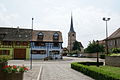
 Rue Principale | |
.svg) Coat of arms | |
Location of Meistratzheim  | |
 Meistratzheim  Meistratzheim | |
| Coordinates: 48°26′58″N 7°32′38″E / 48.4494°N 7.5439°E | |
| Country | France |
| Region | Grand Est |
| Department | Bas-Rhin |
| Arrondissement | Sélestat-Erstein |
| Canton | Obernai |
| Intercommunality | Pays de Sainte-Odile |
| Government | |
| • Mayor (2020–2026) | Claude Krauss[1] |
| Area 1 | 12.82 km2 (4.95 sq mi) |
| Population (2021)[2] | 1,503 |
| • Density | 120/km2 (300/sq mi) |
| Time zone | UTC+01:00 (CET) |
| • Summer (DST) | UTC+02:00 (CEST) |
| INSEE/Postal code | 67286 /67210 |
| Elevation | 150–162 m (492–531 ft) |
| 1 French Land Register data, which excludes lakes, ponds, glaciers > 1 km2 (0.386 sq mi or 247 acres) and river estuaries. | |
Meistratzheim (French pronunciation: [maistʁatsaim]) is a commune in the Bas-Rhin department in Grand Est in north-eastern France.[3]
History
Located near a Celtic-Romanic route connecting Belfort with Brumath, the village has been occupied since the Neolithic.[4] the village is mentioned for the first time in a parchment dating from 742 where it says that the convent of Wissembourg had possessions in Maistersheim.
Initially the village belonged to the Count of Nordgau and from 742 to 1030 to different abbeys. The fief was then acquired by the diocese of Strasbourg and later by the Landsberg family, who held it up to the French Revolution.
During the seventeenth century the village was pillaged by passing Imperial, Swedish, Lorraine and French troops. Famine came because of rigorous winters and poor harvests.
The village was also home to Eugène Grau, who founded a successful family butchers business which continued for several generations. The family also owned a large property used for Monumental masonry.
Points of interest
The catholic church, Saint André, was built from 1911 to 1919, consecrated in 1922 and is at 75 m the highest in Bas-Rhin outside of Strasbourg.
Education
This section needs expansion. You can help by adding to it. (April 2015) |
The Classe de Japonais en Alsace (アルザス補習授業校 Aruzasu Hoshū Jugyō Kō), a part-time Japanese supplementary school, is held in the A.P.E.J.A. in Meistratzheim.[5]
Photo gallery
-
 Town Hall
 -
 Evangelical church
 -
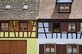 House facades
 -
 Catholic church Saint André
 -
 Madonna at the entrance lintel of Saint André
 -
 Crucifixion group at Rue de L'Eglise
 -
 View of the town from Niedernai


See also
References
- ^ "Répertoire national des élus: les maires" (in French). data.gouv.fr, Plateforme ouverte des données publiques françaises. 13 September 2022.
- ^ "Populations légales 2021". The National Institute of Statistics and Economic Studies. 28 December 2023.
- ^ INSEE commune file
- ^ Pays de Sainte odile Archived 2006-11-28 at the Wayback Machine (French)
- ^ "欧州の補習授業校一覧(平成25年4月15日現在)" (). Ministry of Education, Culture, Sports, Science and Technology (MEXT). Retrieved on May 10, 2014. "A.P.E.J.A. 122 rue Principale 67210 MEISTRATZHEIM , FRANCE"
| International | |
|---|---|
| National | |
| Other | |
This Bas-Rhin geographical article is a stub. You can help Wikipedia by expanding it. |
- CS1 French-language sources (fr)
- Webarchive template wayback links
- Articles with short description
- Short description is different from Wikidata
- Coordinates on Wikidata
- Pages using infobox settlement with image map1 but not image map
- Pages with French IPA
- Articles to be expanded from April 2015
- All articles to be expanded
- Articles using small message boxes
- Commons category link from Wikidata
- Articles with VIAF identifiers
- Articles with BNF identifiers
- Articles with BNFdata identifiers
- Articles with SUDOC identifiers
- Communes of Bas-Rhin
- All stub articles
- Bas-Rhin geography stubs
- Pages using the Kartographer extension