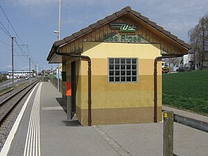
Les Ripes railway station
Jump to navigation
Jump to search
Les Ripes | |||||||||||
|---|---|---|---|---|---|---|---|---|---|---|---|
 The station platform in 2011 | |||||||||||
| General information | |||||||||||
| Location | Étagnières, Vaud Switzerland | ||||||||||
| Coordinates | 46°35′31.884″N 6°36′29.016″E / 46.59219000°N 6.60806000°E | ||||||||||
| Elevation | 623 m (2,044 ft) | ||||||||||
| Owned by | Chemin de fer Lausanne-Échallens-Bercher | ||||||||||
| Line(s) | Lausanne–Bercher line | ||||||||||
| Distance | 9.1 km (5.7 mi) from Lausanne-Flon[1] | ||||||||||
| Platforms | 1 side platform | ||||||||||
| Tracks | 1 | ||||||||||
| Train operators | Chemin de fer Lausanne-Échallens-Bercher | ||||||||||
| Other information | |||||||||||
| Fare zone | 16 (mobilis)[2] | ||||||||||
| Services | |||||||||||
| |||||||||||
| |||||||||||
Les Ripes railway station (French: Halte Les Ripes) is a railway station in the municipality of Étagnières, in the Swiss canton of Vaud. It is located on the 1,000 mm (3 ft 3+3⁄8 in) Lausanne–Bercher line of the Chemin de fer Lausanne-Échallens-Bercher (LEB).[1]
Services
As of the December 2020 timetable change,[update] the following services stop at Les Ripes:[3]
- Regio: service every fifteen minutes between Lausanne-Flon and Echallens, with every other train continuing from Echallens to Bercher.
References
- ^ a b Eisenbahnatlas Schweiz. Cologne: Schweers + Wall. 2012. p. 71. ISBN 978-3-89494-130-7.
- ^ "Plan Mobilis". Mobilis Vaud. Retrieved 13 March 2021.
- ^ "Lausanne-Flon - Echallens - Bercher" (PDF) (in French). Bundesamt für Verkehr. 11 December 2020. Retrieved 13 March 2021.
External links
 Media related to Les Ripes railway station at Wikimedia Commons
Categories:
- Pages using gadget WikiMiniAtlas
- CS1 French-language sources (fr)
- Coordinates on Wikidata
- Pages with no open date in Infobox station
- Articles containing French-language text
- Articles containing potentially dated statements from December 2020
- All articles containing potentially dated statements
- Commons category link from Wikidata
- Railway stations in the canton of Vaud
- Lausanne–Echallens–Bercher Railway stations
- Pages using the Kartographer extension
