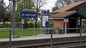
Le Boéchet railway station
Jump to navigation
Jump to search
Le Boéchet | |||||||||||
|---|---|---|---|---|---|---|---|---|---|---|---|
 The station platform in 2019 | |||||||||||
| General information | |||||||||||
| Location | Les Bois, Jura Switzerland | ||||||||||
| Coordinates | 47°11′38″N 6°55′19″E / 47.19389°N 6.92194°E | ||||||||||
| Elevation | 1,033 m (3,389 ft) | ||||||||||
| Owned by | Chemins de fer du Jura | ||||||||||
| Line(s) | La Chaux-de-Fonds–Glovelier line | ||||||||||
| Distance | 27.8 km (17.3 mi) from Tavannes[1] | ||||||||||
| Platforms | 1 side platform | ||||||||||
| Tracks | 1 | ||||||||||
| Train operators | Chemins de fer du Jura | ||||||||||
| Other information | |||||||||||
| Fare zone | 42 (Onde Verte and Vagabond)[2][3] | ||||||||||
| Services | |||||||||||
| |||||||||||
| |||||||||||
Le Boéchet railway station (French: Gare du Boéchet) is a railway station in the municipality of Les Bois, in the Swiss canton of Jura. It is located on the 1,000 mm (3 ft 3+3⁄8 in) La Chaux-de-Fonds–Glovelier line of the Chemins de fer du Jura.[1]
Services
As of the December 2020 timetable change,[update] the following services stop at Le Boéchet:[4]
- Regio: hourly service between La Chaux-de-Fonds and Glovelier.
References
- ^ a b Eisenbahnatlas Schweiz. Cologne: Schweers + Wall. 2012. p. 8. ISBN 978-3-89494-130-7.
- ^ "Plan de zones" (PDF). Onde Verte. December 2019. Retrieved 27 March 2021.
- ^ "Plan de zones tarifaires" (PDF) (in French). Vagabond. 13 December 2020. Retrieved 27 March 2021.
- ^ "La Chaux-de-Fonds – Le Noirmont – Saignelégier – Glovelier" (PDF) (in French). Bundesamt für Verkehr. 24 November 2020. Retrieved 27 March 2021.
External links
 Media related to Le Boéchet railway station at Wikimedia Commons
- Le Boéchet railway station – SBB
Categories:
- Pages using gadget WikiMiniAtlas
- CS1 French-language sources (fr)
- Coordinates on Wikidata
- Pages with no open date in Infobox station
- Pages using infobox station with deprecated parameters
- Articles containing French-language text
- Articles containing potentially dated statements from December 2020
- All articles containing potentially dated statements
- Commons category link from Wikidata
- Railway stations in the canton of Jura
- Chemins de fer du Jura stations
- Pages using the Kartographer extension
