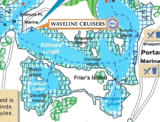
Killinure Lough
Jump to navigation
Jump to search
| Killinure Lough | |
|---|---|
| Loch Choill an Iúir (Irish) | |
 | |
 Killinure Lough | |
| Location | County Westmeath, Ireland |
| Coordinates | 53°27′34″N 7°53′50″W / 53.459369°N 7.897106°W |
| Primary inflows | Breensford River, Coosan Lough, Glassan River |
| Primary outflows | Lough Ree |
| Basin countries | Ireland |
| Surface area | 2.6 km2 (1.0 sq mi) |
| Surface elevation | 36 m (118 ft) |
| Islands | Carberry Island, Temple's Island, Thatch Islands East, Cookanamuck, Garnagh Island, Sramore Islands, |
| Settlements | Glassan, Ballykeevan |
Killinure Lough is a lake in County Westmeath, Ireland, which feeds into Lough Ree on the Shannon.[1][2]
Wildlife
The lough is a brown trout and eel fishery.[3][4]
See also
References
- ^ "Killinure Lough".
- ^ "Killinure Lough - Cruising around Ireland".
- ^ "(map)". kapitaens-handbuch.com.
- ^ C. Moriarty (1971). "Fishery Leaflet No. 2: Eel research in 190" (PDF). Department of Agriculture and Fisheries.
This article related to the geography of County Westmeath, Ireland is a stub. You can help Wikipedia by expanding it. |
Categories:
- Pages using gadget WikiMiniAtlas
- Articles with short description
- Short description matches Wikidata
- Use dmy dates from March 2021
- Use Hiberno-English from March 2021
- All Wikipedia articles written in Hiberno-English
- Articles containing Irish-language text
- Coordinates on Wikidata
- Articles using infobox body of water without alt
- Articles using infobox body of water without pushpin map alt
- Articles using infobox body of water without image bathymetry
- Lakes of County Westmeath
- All stub articles
- County Westmeath geography stubs