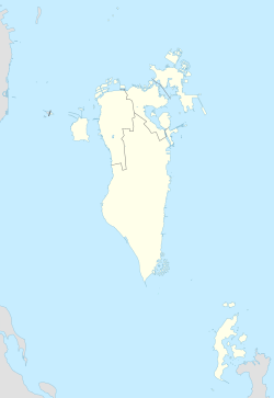
Janabiyah
Janabiyah
الجنبية | |
|---|---|
Village | |
| Coordinates: 26°10′59″N 50°27′58″E / 26.183°N 50.466°E | |
| Country | Kingdom of Bahrain |
| Governorate | Northern Governorate |
Janabiyah (Arabic:الجنبية) is a village situated in the north-west of Bahrain, close to the Gulf of Bahrain. It is located south of Bani Jamra and to the west of the village of Saar. It is under the Northern Governorate administrative region of the country. The village is mainly popular for its camel farms that host around 100 camels.[1]
History
Janabiyah is home to hundreds of ancient burial mounds dating back to 2200 BC, during the Dilmun era of Bahraini history. The site is regarded by archaeologists as being "one of the most important heritage sites in the country".[2] People buried in Janabiya were believed to have resided in the nearby villages of Saar and Budaiya since northern Bahrain was agriculturally rich. The Dilmunite practice was to bury the dead in central Bahrain in locations like Hamad Town, because of the dryness of the area however it was not always the case.[2] The mounds were constructed from sand and limestone, obtained from nearby surroundings. Excavations at Janabiyah during 2005 yielded around forty-five artifacts, including Dilmun trade seals, pottery, shells, ostrich eggs, daggers, beads, baskets and 2 complete human skeletons.[2]
Artifacts dating to the Dilmun era over 4,000 years ago were uncovered at a burial mound in Janabiyah in 2005.[2] Trade seals with Indus Valley inscriptions were discovered, strengthening archaeologists' beliefs about the existence of regular trade between the Dilmun and Indus Valley civilisations respectively.[2] The seals were found in a large burial mound that was believed to have been built for wealthy or religious people.[2]
In J. G. Lorimer's Gazetteer of the Persian Gulf (1908), he writes that Janabiyah consisted of 20 huts inhabited by the Baharna, who were either fishermen or farmers. There were an estimated 1000 date palms, 8 donkey and 2 cows in the village.[3]
Facilities
Aside from the camel farm, the village is also host to multiple resorts and fitness centres.[4] The Birla Institute of Technology International Centre is based alongside the Janabiyah highway.[5] Sanabil private school was situated in the village prior to its closure, as well as the children's academy for the disabled.[6][7][8]
Janabiyah hosts a two-story substation which is currently undergoing renovations that will install a 4000kV project. This will accommodate two transformers of 1,500kV each on the ground floor and main isolation and contact devices and four main low-voltage distribution boards.[9]
References
- ^ "Bahrain Attractions". Click Bahrain. Archived from the original on 12 September 2012. Retrieved 26 August 2012.
- ^ a b c d e f Torr, Rebecca (6 June 2005). "Investigations by archaeologists in Bahrain are unearthing new evidence of ancient trading links". Gulf Daily News. Retrieved 26 August 2012.
- ^ Lorimer, John Gordon. "'Gazetteer of the Persian Gulf. Vol. II. Geographical and Statistical. J G Lorimer. 1908' [221] (244/2084)". Qatar Digital Library. British Library: India Office Records and Private Papers. Retrieved 13 September 2015.
- ^ "25 visit Janabiya health resort". Gulf Daily News. 20 February 2005. Retrieved 26 August 2012.
- ^ "Contact BIT Campuses". Birla Institute of Technology. Archived from the original on 8 September 2012. Retrieved 26 August 2012.
- ^ "Cream of talent". Gulf Daily News. Retrieved 26 August 2012.
- ^ "Academy for disabled children opens". Gulf Daily News. 12 March 2009. Retrieved 26 August 2012.
- ^ Alghata, Laala (19 Jul 2017). "Licence for Sanabil Private School revoked". Gulf Digital News. Retrieved 1 July 2020.
- ^ "Bahrain to expand power distribution system". Trade Arabia. 26 August 2012. Retrieved 26 August 2012.
