Inchoun
Inchoun
Инчоун | |
|---|---|
Location of Inchoun  | |
 Inchoun Location of Inchoun  Inchoun Inchoun (Chukotka Autonomous Okrug) | |
| Coordinates: 66°18′N 170°17′W / 66.300°N 170.283°W | |
| Country | Russia |
| Federal subject | Chukotka Autonomous Okrug[1] |
| Administrative district | Chukotsky District |
| Population | |
| • Total | 387 |
| • Estimate (January 2018)[4] | 365 |
| • Municipal district | Chukotsky Municipal District[5] |
| • Rural settlement | Inchoun Rural Settlement[5] |
| • Capital of | Inchoun Rural Settlement[5] |
| Time zone | UTC+12 (MSK+9 |
| Postal code(s)[7] | 689313 |
| Dialing code(s) | +7 42736[8] |
| OKTMO ID | 77633410101 |
Inchoun (Russian: Инчоун, Chukchi: И’нчувин,[9] I’nčuvin; Yupik: Инсиг’вик[9]) is a rural locality (a selo) in Chukotsky District of Chukotka Autonomous Okrug, Russia.[1] It is located on the shores of the Chukchi Sea, about 25 kilometers (16 mi) west of Uelen. Population: 387 (2010 Russian census);[2] [3] Municipally Inchoun is subordinated to Chukotsky Municipal District and is incorporated as Inchoun Rural Settlement.[5]
History
Pre-history
The name of the village comes from the Chukchi word I'nchuvin, meaning "a cut-off nose tip". This strange appellation is derived from a nearby cliff with a large rock at its base that is said to look like a nose cut from a face.[10] There is a Chukchi dancing troupe in the village called Vyrykvyn.[9]
Excavations carried out by the Museum of Chukotka Heritage Centre and the State Museum of Northern Art at the Palpeygak (Russian: Пальпейгак) site (named after a nearby eponymous creek) revealed finds indicating that the area had been inhabited for the last 3000 years[11]
Twentieth Century
In 1945 Inchoun had the best Soviet reading rooms in the Okrug.[11] In the 1950s, construction began on wooden houses in the village and by 1957, the first nine families moved out of their Yaranga and into these new houses.[11]
Demographics
The population of the village as of 2009 was 398[11] an increase on the estimate in 2008 of 365,[9] which itself was down from the figure given in March 2003 of 373 (of which 353 were indigenous peoples).[12] The official census results indicate a slight reduction on the 2009 estimate to 387,[2] of whom 185 were male and 202 female.[3]
Transport
Inchoun is 150 miles from the district centre Lavrentiya[11] and is not connected to any other part of the world by permanent road. However, there is a small network of roads within the settlement including:[13]
- Улица Ачиргина (Ulitsa Achyrgyna)
- Улица Коммунистическая (Ulitsa Kommunisticheskaya, lit. Communist Street)
- Улица Морзверобоев (Ulitsa Morzveroboyev, li. Walrus-hunting Brigade Street)
- Улица Тенетегина (Ulitsa Tenetegina)
- Улица Центральная (Ulitsa Tsentralnaya, lit. Central Street)
- Улица Шипина (Ulitsa Shipina)
- Улица Школьная (Ulitsa Shkolnaya, lit. School Street)
Climate
Inchoun has a Tundra climate (ET)[14] because the warmest month has an average temperature between 0 °C (32 °F) and 10 °C (50 °F).
| Climate data for Inchoun | |||||||||||||
|---|---|---|---|---|---|---|---|---|---|---|---|---|---|
| Month | Jan | Feb | Mar | Apr | May | Jun | Jul | Aug | Sep | Oct | Nov | Dec | Year |
| Record high °C (°F) | 4.7 (40.5) |
5.5 (41.9) |
3.9 (39.0) |
6.4 (43.5) |
10.5 (50.9) |
18.4 (65.1) |
22.7 (72.9) |
22 (72) |
16.3 (61.3) |
12 (54) |
8.7 (47.7) |
10 (50) |
22.7 (72.9) |
| Mean daily maximum °C (°F) | −17.9 (−0.2) |
−16.7 (1.9) |
−15.8 (3.6) |
−9.1 (15.6) |
−0.7 (30.7) |
5.6 (42.1) |
10 (50) |
9.2 (48.6) |
5.4 (41.7) |
0.5 (32.9) |
−4.7 (23.5) |
−13.9 (7.0) |
−4 (25) |
| Mean daily minimum °C (°F) | −23.9 (−11.0) |
−22.8 (−9.0) |
−22.3 (−8.1) |
−15.2 (4.6) |
−4.6 (23.7) |
1 (34) |
4.8 (40.6) |
4.8 (40.6) |
2.2 (36.0) |
−3 (27) |
−9.8 (14.4) |
−19 (−2) |
−9 (16) |
| Record low °C (°F) | −44.1 (−47.4) |
−41.5 (−42.7) |
−41.4 (−42.5) |
−31.1 (−24.0) |
−24.5 (−12.1) |
−5.6 (21.9) |
−4.7 (23.5) |
−2.7 (27.1) |
−6.1 (21.0) |
−19.9 (−3.8) |
−33.6 (−28.5) |
−41.2 (−42.2) |
−44.1 (−47.4) |
| Average rainfall mm (inches) | 19 (0.7) |
20 (0.8) |
13.8 (0.54) |
18.1 (0.71) |
18.8 (0.74) |
15.1 (0.59) |
40.4 (1.59) |
46.2 (1.82) |
35.9 (1.41) |
45.4 (1.79) |
28.8 (1.13) |
18.4 (0.72) |
319.9 (12.59) |
| Average snowy days | 14 | 12 | 11 | 15 | 13 | 3 | 0 | 0 | 4 | 17 | 20 | 15 | 124 |
| Source: [15] | |||||||||||||
Photo gallery
-
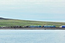 Inchoun Village (Chukchi Sea, Russia;
66°17’56‘‘N, 170°17‘6‘‘W) -
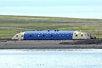 Inchoun Village, schoolhouse
 -
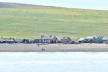 Inchoun Village
 -
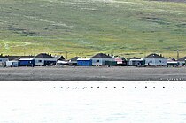 Inchoun Village


See also
References
Notes
- ^ a b c d Law #33-OZ, Article 13.2 (in Russian)
- ^ a b c Russian Federal State Statistics Service (2011). Всероссийская перепись населения 2010 года. Том 1 [2010 All-Russian Population Census, vol. 1]. Всероссийская перепись населения 2010 года [2010 All-Russia Population Census] (in Russian). Federal State Statistics Service.
- ^ a b c The results of the 2010 Census are given for Inchoun Rural Settlement, a municipal formation of Chukotsky Municipal District. According to Law #148-OZ, Inchoun is the only inhabited locality on the territory of Inchoun Rural Settlement.
- ^ Office of the Federal State Statistics Service for Khabarovsk Krai, Magadan Oblast, Jewish Autonomous Oblast and Chukotka Autonomous Okrug. Численность населения Чукотского автономного округа по муниципальным образованиям на 1 января 2018 года Archived 2019-08-31 at the Wayback Machine (in Russian)
- ^ a b c d Law #47-OZ, Article 2 (in Russian)
- ^ "Об исчислении времени". Официальный интернет-портал правовой информации (in Russian). 3 June 2011. Retrieved 19 January 2019.
- ^ Почта России. Информационно-вычислительный центр ОАСУ РПО. (Russian Post). Поиск объектов почтовой связи (Postal Objects Search) (in Russian)
- ^ Ministry of Justice of the Russian Federation Archived 2012-02-08 at the Wayback Machine Chukotsky District (in Russian)
- ^ a b c d Inchoun Information Archived 2012-03-29 at the Wayback Machine, Beringia Nature Park Website. Retrieved 12 April 2012
- ^ Strogoff, p.120
- ^ a b c d e Муниципальное образование сельское поселение Инчоун Archived 2010-07-25 at the Wayback Machine Municipal Formation of the Rural Settlement of Inchoun - Official Website of Chukotsky District]
- ^ Red Cross of Chukotka. Chukotsky District (Archived)
- ^ Pochtovik Mail Delivery Service[permanent dead link] Inchoun - Chukotsky District (in Russian)
- ^ McKnightand Hess, pp.235-7
- ^ "Weather Averages for Inchoun from meoweather.com". meoweather.com. Retrieved October 2, 2012.
Sources
- McKnight, Tom L; Hess, Darrel (2000). "Climate Zones and Types". Physical Geography: A Landscape Appreciation. Upper Saddle River, NJ: Prentice Hall. ISBN 0-13-020263-0.
- Дума Чукотского автономного округа. Закон №33-ОЗ от 30 июня 1998 г. «Об административно-территориальном устройстве Чукотского автономного округа», в ред. Закона №55-ОЗ от 9 июня 2012 г. «О внесении изменений в Закон Чукотского автономного округа "Об административно-территориальном устройстве Чукотского автономного округа"». Вступил в силу по истечении десяти дней со дня его официального опубликования. Опубликован: "Ведомости", №7 (28), 14 мая 1999 г. (Duma of Chukotka Autonomous Okrug. Law #33-OZ of June 30, 1998 On the Administrative-Territorial Structure of Chukotka Autonomous Okrug, as amended by the Law #55-OZ of June 9, 2012 On Amending the Law of Chukotka Autonomous Okrug "On the Administrative-Territorial Structure of Chukotka Autonomous Okrug". Effective as of after ten days from the day of the official publication.). (in Russian)
- Дума Чукотского автономного округа. Закон №47-ОЗ от 29 ноября 2004 г. «О статусе, границах и административных центрах муниципальных образований на территории Чукотского района Чукотского автономного округа». Вступил в силу через десять дней со дня официального опубликования. Опубликован: "Ведомости", №31/1 (178/1), 10 декабря 2004 г. (Duma of Chukotka Autonomous Okrug. Law #47-OZ of November 29, 2004 On the Status, Borders, and Administrative Centers of the Municipal Formations on the Territory of Chukotsky District of Chukotka Autonomous Okrug. Effective as of the day which is ten days after the official publication date.). (in Russian)
- Strogoff, M, Brochet, P-C and Auzias, D. Petit Futé: Chukotka, "Avant-Garde" Publishing House, 2006.
- Pages using gadget WikiMiniAtlas
- Articles with Russian-language sources (ru)
- CS1 uses Russian-language script (ru)
- CS1 Russian-language sources (ru)
- Webarchive template wayback links
- All articles with dead external links
- Articles with dead external links from January 2020
- Articles with permanently dead external links
- Articles with short description
- Short description is different from Wikidata
- Infobox mapframe without OSM relation ID on Wikidata
- Coordinates on Wikidata
- Pages using infobox settlement with image map1 but not image map
- Pages using infobox Russian inhabited locality with unknown parameters
- Articles containing Russian-language text
- Articles containing Chukot-language text
- Rural localities in Chukotka Autonomous Okrug
- Chukchi Sea
- Pages using the Kartographer extension