Húcares
Húcares | |
|---|---|
Barrio | |
 Shops in Húcares | |
 Location of Húcares within the municipality of Naguabo shown in red | |
 Húcares Location of Puerto Rico | |
| Coordinates: 18°11′49″N 65°43′07″W / 18.197052°N 65.718543°W[1] | |
| Commonwealth | |
| Municipality | |
| Area | |
| • Total | 3.14 sq mi (8.1 km2) |
| • Land | 2.45 sq mi (6.3 km2) |
| • Water | 0.69 sq mi (1.8 km2) |
| Elevation | 171 ft (52 m) |
| Population (2010) | |
| • Total | 2,918 |
| • Density | 1,191/sq mi (460/km2) |
| Source: 2010 Census | |
| Time zone | UTC−4 (AST) |
| ZIP Codes | 00736 |
| Area code | 787/939 |
Húcares is a barrio in the municipality of Naguabo, Puerto Rico. Its population in 2010 was 2,918.[3][4][5]
History
Húcares was in Spain's gazetteers[6] until Puerto Rico was ceded by Spain in the aftermath of the Spanish–American War under the terms of the Treaty of Paris of 1898 and became an unincorporated territory of the United States. In 1899, the United States Department of War conducted a census of Puerto Rico finding that the population of Húcares barrio was 826.[7]
| Census | Pop. | Note | %± |
|---|---|---|---|
| 1900 | 826 | — | |
| 1910 | 783 | −5.2% | |
| 1920 | 906 | 15.7% | |
| 1930 | 1,233 | 36.1% | |
| 1940 | 1,132 | −8.2% | |
| 1950 | 1,694 | 49.6% | |
| 1960 | 1,743 | 2.9% | |
| 1970 | 0 | −100.0% | |
| 1980 | 1,418 | — | |
| 1990 | 1,435 | 1.2% | |
| 2000 | 2,118 | 47.6% | |
| 2010 | 2,918 | 37.8% | |
| U.S. Decennial Census 1899 (shown as 1900)[8] 1910-1930[9] 1930-1950[10] 1980-2000[11] 2010[12] | |||
Features
Playa Húcares in Húcares is not a beach per se but is a tourist attraction because of its boardwalk, fishing activities and seafood restaurants.[13]
-
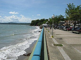 Boardwalk in Húcares

Sectors
Barrios (which are, in contemporary times, roughly comparable to minor civil divisions)[14] in turn are further subdivided into smaller local populated place areas/units called sectores (sectors in English). The types of sectores may vary, from normally sector to urbanización to reparto to barriada to residencial, among others.[15][16][17]
The following sectors are in Húcares barrio:[18]
Calle Punta Lima, Estancias de Húcares, Hacienda El Triunfo, Las Mercedes (Calle de la Playa), Mansiones de Playa Húcares, Parcelas Invasión, Parcelas Nuevas, Parcelas Playa, Residencial Húcares I y II, Sector Calle del Pueblo, Sector Cambímbora, Sector El Faro, Sector Fanduca, Sector La Changa, Sector La Ola, Urbanización Cala de Húcares, Urbanización Jardín del Este, Urbanización Lomas de Santo Tomás, Urbanización Los Valles, Urbanización Mar Caribe, and Urbanización Santo Tomás.
See also
References
- ^ a b "US Gazetteer 2019". US Census. US Government.
- ^ U.S. Geological Survey Geographic Names Information System: Húcares barrio
- ^ Picó, Rafael; Buitrago de Santiago, Zayda; Berrios, Hector H. Nueva geografía de Puerto Rico: física, económica, y social, por Rafael Picó. Con la colaboración de Zayda Buitrago de Santiago y Héctor H. Berrios. San Juan Editorial Universitaria, Universidad de Puerto Rico,1969.
- ^ Gwillim Law (20 May 2015). Administrative Subdivisions of Countries: A Comprehensive World Reference, 1900 through 1998. McFarland. p. 300. ISBN 978-1-4766-0447-3. Retrieved 25 December 2018.
- ^ Puerto Rico: 2010 Population and Housing Unit Counts.pdf (PDF). U.S. Dept. of Commerce, Economics and Statistics Administration, U.S. Census Bureau. 2010.
- ^ "Anuario del comercio, de la industria, de la magistratura y de la administración. 1881". Biblioteca Nacional de España (in Spanish). p. 1614. Retrieved 4 April 2023.
- ^ Joseph Prentiss Sanger; Henry Gannett; Walter Francis Willcox (1900). Informe sobre el censo de Puerto Rico, 1899, United States. War Dept. Porto Rico Census Office (in Spanish). Imprenta del gobierno. p. 163.
- ^ "Report of the Census of Porto Rico 1899". War Department Office Director Census of Porto Rico. Archived from the original on July 16, 2017. Retrieved September 21, 2017.
- ^ "Table 3-Population of Municipalities: 1930 1920 and 1910" (PDF). United States Census Bureau. Archived (PDF) from the original on August 17, 2017. Retrieved September 21, 2017.
- ^ "Table 4-Area and Population of Municipalities Urban and Rural: 1930 to 1950" (PDF). United States Census Bureau. Archived (PDF) from the original on August 30, 2015. Retrieved September 21, 2014.
- ^ "Table 2 Population and Housing Units: 1960 to 2000" (PDF). United States Census Bureau. Archived (PDF) from the original on July 24, 2017. Retrieved September 21, 2017.
- ^ Puerto Rico: 2010 Population and Housing Unit Counts.pdf (PDF). U.S. Dept. of Commerce Economics and Statistics Administration U.S. Census Bureau. 2010. Archived (PDF) from the original on 2017-02-20. Retrieved 2019-08-02.
- ^ "Playa Húcares, Naguabo, Puerto Rico". BoricuaOnline.com (in Spanish). 2019-09-19. Retrieved 2021-01-23.
- ^ "US Census Barrio-Pueblo definition". factfinder.com. US Census. Archived from the original on 13 May 2017. Retrieved 5 January 2019.
- ^ "Agencia: Oficina del Coordinador General para el Financiamiento Socioeconómico y la Autogestión (Proposed 2016 Budget)". Puerto Rico Budgets (in Spanish). Retrieved 28 June 2019.
- ^ Rivera Quintero, Marcia (2014), El vuelo de la esperanza: Proyecto de las Comunidades Especiales Puerto Rico, 1997-2004 (first ed.), San Juan, Puerto Rico Fundación Sila M. Calderón, ISBN 978-0-9820806-1-0
- ^ "Leyes del 2001". Lex Juris Puerto Rico (in Spanish). Retrieved 24 June 2020.
- ^ "PRECINTO ELECTORAL Naguabo 095" (PDF). Comisión Estatal de Elecciones (in Spanish). PR Government. 1 August 2008. Archived (PDF) from the original on 28 August 2020. Retrieved 27 August 2020.
This Naguabo, Puerto Rico location article is a stub. You can help Wikipedia by expanding it. |
- CS1 Spanish-language sources (es)
- Articles with short description
- Short description is different from Wikidata
- Short description matches Wikidata
- Coordinates on Wikidata
- Articles containing Spanish-language text
- Barrios of Naguabo, Puerto Rico
- All stub articles
- Puerto Rico senatorial district VII geography stubs