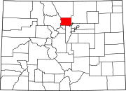
Gooding, Colorado
Jump to navigation
Jump to search
Gooding, Colorado | |
|---|---|
| Coordinates: 40°04′25″N 105°04′59″W / 40.07361°N 105.08306°W | |
| Country | United States |
| State | Colorado |
| County | Boulder |
| Elevation | 5,007 ft (1,526 m) |
| Time zone | UTC-7 (Mountain (MST)) |
| • Summer (DST) | UTC-6 (MDT) |
| Area code(s) | 303 & 720 |
| GNIS feature ID | 178727[1] |
Gooding is an unincorporated community in Boulder County, Colorado, United States.[1]
History
The Gooding School was established sometime between 1945 and 1956, near the banks of Boulder Creek.[2] Gooding did not appear on topographic maps as a settlement until 1967.[3]
References
- ^ a b "Gooding, Colorado". Geographic Names Information System. United States Geological Survey, United States Department of the Interior.
- ^ United States Geological Survey (1956). Erie Quadrangle, Colorado (Map). United States Department of the Interior. Retrieved September 8, 2021.
- ^ United States Geological Survey (1967). Erie Quadrangle, Colorado (Map). United States Department of the Interior. Retrieved September 8, 2021.
Categories:
- Use mdy dates from July 2023
- Articles with short description
- Short description is different from Wikidata
- Coordinates on Wikidata
- Pages using infobox settlement with possible area code list
- Unincorporated communities in Boulder County, Colorado
- Unincorporated communities in Colorado
- All stub articles
- Colorado geography stubs


