Giovan Battista Nicolosi
Giovan Battista Nicolosi | |
|---|---|
| Born | 14 October 1610 |
| Died | 19 January 1670 (aged 59) |
| Nationality | Sicilian |
| Occupation(s) | Geographer and scholar |
| Known for | Nicolosi globular projection |
| Parent(s) | Antonio Nicolosi and Antonina Nicolosi (née Corsaro) |
| Academic background | |
| Influences | |
| Academic work | |
| Era | Scientific Revolution |
| Discipline |
|
| Institutions | Sapienza University of Rome Sacred Congregation for the Propagation of the Faith |
| Influenced | |
Giovan Battista Nicolosi, D.D., was a Sicilian priest and geographer. Nicolosi proposed a new projection for the construction of the world map in two hemispheres, known today as the Nicolosi globular projection, in which the parallels and meridians are arcs of the circle and equidistant along the equator and central meridian.[5]
Biography
Early life
Giovan Battista Nicolosi was born in Paternò, on October 14, 1610, of poor parents. He was the second child in a family of ten siblings.[1]
In 1640 Nicolosi moved to Rome,[6] where he devoted himself to the study of mathematics and geography and quickly gained favor with the city's most powerful families.[1] In 1642, he published his Teorica del Globo Terrestre ("Theory of the Terrestrial Globe"), a small geographical treatise in which he adopts the tripartite division of the subject into mathematical, physical, and political geography, usually credited to Varenius. Although in his unpublished works he showed leanings towards the new views of Copernicus, he does not here venture to break away from the Ptolemaic system, no doubt owing to his character as a devout son of the Church.
Career
_-_componebat_Joa._Baptista_Nicolosius..._-_btv1b53093265h.jpg)
The Theory of the Terrestrial Globe brought Nicolosi to the attention of broader scientific circles and earned him the Chair in Geography at Sapienza University of Rome. In late 1645, Nicolosi travelled to Germany at the invitation of Ferdinand Maximilian, margrave of Baden, where he remained until 1647.[7] In 1647 he returned to Rome, and was appointed chaplain at Santa Maria Maggiore.[1] In 1652, possibly motivated by Nicolas Sanson's new collection of maps, the Sacred Congregation for the Propagation of the Faith (Propaganda Fide) hired Nicolosi to compose a new atlas. After twelve years of study and research, he published the Dell’Hercole e studio geografico, in two volumes with maps and directions for making maps and globes.[5] The first volume was principally occupied with a detailed description of the countries of the world, while the second formed an atlas of twenty-two newly devised maps — two of the hemispheres, and four devoted to each of the five continents. In this atlas Nicolosi was the first to employ the so-called polyconic or pseudo-perspective projection on a printed map.[8] This projection technique was suggested in the eleventh century by the Persian mathematician al-Bīrūnī.[9] Nicolosi reinvented al-Bīrūnī's projection as a modification of Fournier's first projection. It is unlikely Nicolosi knew of al-Bīrūnī's work, and Nicolosi's name is the one usually associated with the projection.[10] This became a standard method of showing the two hemispheres of Earth during the nineteenth century after the equatorial stereographic projection popularized by Gerardus Mercator finally fell into disuse.[10]
Nicolosi also undertook for Pope Alexander VII and the Emperor Leopold I the mapping of the States of the Church and the Kingdom of Naples, besides making five large maps for Prince Borghese.[1] Nicolosi's last published work is Guida allo studio geografico ("Guide to geographic study"), a small treatise designed to supplement and explain the other two. He died in Rome on January 19, 1670.[1]
Works
.jpg)
- Nicolosi, Giovan Battista (1642). Teorica del globo terrestre et esplicatione della Carta da Navigare. Roma: per Manelfo Manelfi. Retrieved 12 September 2019.
- Nicolosi, Giovan Battista (1660). Dell'Hercole e studio geografico. Vol. 1. Roma: Nella stamperia di Vitale Mascardi. Retrieved 12 September 2019.
- Nicolosi, Giovan Battista (1660). Dell'Hercole e studio geografico. Vol. 2. Roma: Nella stamperia di Vitale Mascardi. Retrieved 12 September 2019.
- Nicolosi, Giovan Battista (1662). Guida allo studio geografico. Roma: Appresso Vitale Mascardi. Retrieved 12 September 2019.
- Nicolosi, Giovan Battista (1670). Hercules Siculus sive Studium Geographicum (in Latin). Vol. 1. Roma: typis Michaëlis Herculis. Retrieved 12 September 2019.
- Nicolosi, Giovan Battista (1671). Hercules Siculus sive Studium Geographicum (in Latin). Vol. 2. Roma: typis Michaëlis Herculis. Retrieved 12 September 2019.
There exists in the Biblioteca Casanatense a considerable collection of Nicolosi’s unpublished work. This includes a large chorographic map of all of Christendom, commissioned by Pope Alexander VII, as well as a full geographic description and map of the Kingdom of Naples, which was sent to Holy Roman Emperor Leopold I in 1654 and an important relation of his trip to Germany (Viagio di Germania in tante lettere al cardinale Rinaldo d’Este e Parentele della casa di Baden con le corone e principi di Europa).[3]
Gallery of images
-
 World map as it appears in Nicolosi's Dell'Hercole e studio geografico, 1660
 -
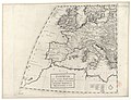 Nicolosi's map of Western Europe, 1660, Département Cartes et plans, Bibliothèque nationale de France, Paris
 -
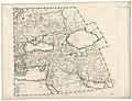
 Nicolosi's map of Spain, 1660, Département Cartes et plans, Bibliothèque nationale de France, Paris
 -
 Nicolosi's map of France, 1660, University Library, University of Illinois Urbana-Champaign
 -
 Nicolosi's map of Italy, 1660, Département Cartes et plans, Bibliothèque nationale de France, Paris
 -
 Nicolosi's map of Middle East, 1660, Département Cartes et plans, Bibliothèque nationale de France, Paris
 -
 Indian subcontinent map by Nicolosi, 1660, Département Cartes et plans, Bibliothèque nationale de France, Paris
 -
 Nicolosi's map of Borneo, 1660, Département Cartes et plans, Bibliothèque nationale de France, Paris
_Continentem_Noviter_Detectam,_1660.jpg)
.jpg)
.jpg)
.jpg)
.jpg)
.jpg)
.jpg)
.jpg)
References
Notes
- ^ a b c d e f g Ottaviani 2013.
- ^ Betz, Richard L. (2007). The Mapping of Africa A Cartobibliography of Printed Maps of the African Continent to 1700. Brill. p. 68. ISBN 9789061944898.
- ^ a b Aversano 2018.
- ^ Craig, Thomas (1882). A Treatise on Projections. Washington: Government Printing Office. p. 97.
- ^ a b Matthew H. Edney; Mary Sponberg Pedley, eds. (2020). The History of Cartography. Vol. 4. Chicago and London: The University of Chicago Press. pp. 830–831. ISBN 9780226339221.
- ^ Spinelli 1930, p. 351.
- ^ Hilgers 1997.
- ^ Fiorini, Matteo (1891). "Le proiezioni cartografiche di Albiruni". Bollettino della Società geografica italiana. 3. IV: 294.
- ^ Snyder 1993, p. 14.
- ^ a b Snyder 1993, p. 41.
- ^ Burden, Philip D. (1996). The Mapping of North America: A List of Printed Maps 1511–1670. London: Raleigh Publications. p. 455.
Bibliography
- Mongitore, Antonio (1708). Bibliotheca sicula. Vol. I. Palermo. pp. 332–334.
- Ortolani, Giuseppe Emanuele (1819). Biografia degli uomini illustri della Sicilia. Vol. III. Naples: Gervasi.
- McClintock, John; Strong, James (1894). "Nicolosius, Johannes Baptista". Cyclopædia of Biblical, Theological, and Ecclesiastical Literature. Vol. 7. New York: Harper & Brothers. p. 80.
- Savasta, Gaetano (1898). Della vita e degli scritti di Giambattista Nicolosi. Paternò: Tipografia Placido Bucolo.
- Giardina, Francesco Saverio (1924). "Un bel nome siciliano nella storia della Geografia: G.B. Nicolosi". Atti del IX Congresso Geografico Italiano. II. Genoa: 366–371.
- Spinelli, Luisa (1930). "La carta del Reame di Napoli di Giovan Battista Nicolosi". Atti Dell'XI Congresso Geografico Italiano. 2. Naples: 351–354.
- Di Matteo, Salvo (1977). Un geografo siciliano del XVII secolo: Giovan Battista Nicolosi. Peternò: Centro Studi “G. B. Nicolosi”.
- Brancaccio, Giovanni (1991). Geografia, cartografia e storia del Mezzogiorno. Napoli: Guida Editori. pp. 169–171. ISBN 978-8878351219.
- Snyder, John P. (1993). Flattening the earth: two thousand years of map projections. University of Chicago Press. ISBN 0-226-76746-9.
- Hilgers, Robert (1997). Die Deutschlandreise des Giovan Battista Nicolosi: erstmals aus seinem Handschriften herausgegeben, kommentiert und eingeleitet. Rheinfelden: Schäuble. ISBN 3877187811.
- Feeman, Timothy G. (2002). Portraits of the Earth: A Mathematician Looks at Maps. American Mathematical Soc. p. 47. ISBN 9780821872611.
- Aversano, Vincenzo (2018). "Nicolosi, Giovan Battista". In D’Ascenzo, Annalisa (ed.). Digital DISCI. Il Portale del Dizionario storico dei cartografi italiani. Rome: Labgeo Caraci. ISBN 978-88-941810-6-7.
- Polto, Corradina (2019). "Giovan Battista Nicolosi, un Geografo siciliano tra tradizione e innovazione culturale". Humanities. VIII (16): 109–125. doi:10.6092/2240-7715/2019.2.109-125.
External links
- Ottaviani, Alessandro (2013). "NICOLOSI, Giovan Battista". Dizionario Biografico degli Italiani, Volume 78: Natta–Nurra (in Italian). Rome: Istituto dell'Enciclopedia Italiana. ISBN 978-8-81200032-6.
- Giovan Battista Nicolosi entry (in Italian) by Roberto Almagià in the Enciclopedia Treccani, 1934
| International | |
|---|---|
| National | |
| People | |
| Other | |
- Articles with short description
- Short description matches Wikidata
- Pages using infobox person with multiple parents
- Articles with hCards
- CS1 Latin-language sources (la)
- Commons category link from Wikidata
- CS1 Italian-language sources (it)
- Articles with Italian-language sources (it)
- Articles with FAST identifiers
- Articles with ISNI identifiers
- Articles with VIAF identifiers
- Articles with WorldCat Entities identifiers
- Articles with BNE identifiers
- Articles with BNF identifiers
- Articles with BNFdata identifiers
- Articles with GND identifiers
- Articles with ICCU identifiers
- Articles with J9U identifiers
- Articles with KBR identifiers
- Articles with LCCN identifiers
- Articles with NKC identifiers
- Articles with NLA identifiers
- Articles with PLWABN identifiers
- Articles with VcBA identifiers
- Articles with DBI identifiers
- Articles with DTBIO identifiers
- Articles with Trove identifiers
- Articles with SUDOC identifiers
- Writers from Sicily
- 17th-century geographers
- 17th-century Italian scientists
- 17th-century male writers
- 17th-century Italian cartographers
- 1610 births
- 1670 deaths
- Academic staff of the Sapienza University of Rome
- People from Paternò
- Italian geographers
- Catholic clergy scientists