Garwood, Texas
Garwood, Texas | |
|---|---|
 Garwood, Texas Location within the state of Texas  Garwood, Texas Garwood, Texas (the United States) | |
| Coordinates: 29°26′59″N 96°23′49″W / 29.44972°N 96.39694°W | |
| Country | United States |
| State | Texas |
| County | Colorado |
| Elevation | 154 ft (47 m) |
| Time zone | UTC-6 (Central (CST)) |
| • Summer (DST) | UTC-5 (CDT) |
| ZIP code | 77442 |
| Area code | 979 |
| GNIS feature ID | 1336419[1] |
Garwood is an unincorporated community and census designated place (CDP) in Colorado County, Texas, United States. According to the Handbook of Texas, the community had a population of 975 in 2000.
History
The Red Bluff Irrigation System was constructed in 1896 by Marcus H. Townsend, W. T. Burford, and T. A. Hill to draw rice farmers to the region. By 1901, several local farmers were cultivating rice. Ed R. Frnka moved the first building on the townsite in 1901 as well; Townsend offered Frnka the property for his building. In memory of Townsend's friend and Houston lawyer Hiram Morgan Garwood, the community was renamed Garwood. The first chapel and post office in the village were founded in 1901. An extra structure was relocated to Garwood in 1902 and put to use as a hotel. Garwood participated in a land advertising scam in 1906. Agents would give photos of crops, such as orange groves, to their victims that had been taken somewhere else but were purportedly from Colorado County. Unseen, the land was purchased, and most purchasers departed upon seeing Garwood and the surrounding acreage. 1909–1912 saw Garwood publish two newspapers. In 1910, there was a bank there, and 500 people were living in Garwood. The Gulf, Colorado and Santa Fe Railway served the town, which had 750 persons by 1915. The majority of the establishments on the east side of the main street were destroyed by fire in 1922. After these were restored, the town expanded gradually. Garwood recorded twelve establishments and a 975-person population estimate in 1990 and 2000, with 37 businesses.[2] It stayed at 975 in 2010 then went down to 510 in 2020.[3]
Although it is unincorporated, Garwood has a post office with the ZIP code 77442.[4]
Geography
Garwood is situated at the junction of Texas State Highway 71 and Farm to Market Road 950 in southern Colorado County, 13 mi (21 km) southwest of Eagle Lake, 20 mi (32 km) south of Columbus, and 17 mi (27 km) north of El Campo.[3]
There is a bridge on FM 950 that crosses the Colorado River.
Demographics
| Census | Pop. | Note | %± |
|---|---|---|---|
| 2020 | 510 | — | |
| U.S. Decennial Census[5] 1850–1900[6] 1910[7] 1920[8] 1930[9] 1940[10] 1950[11] 1960[12] 1970[13] 1980[14] 1990[15] 2000[16] 2010[17] | |||
Garwood first appeared as a census designated place in the 2020 U.S. Census.[18][17]
2020 census
| Race / Ethnicity (NH = Non-Hispanic) | Pop 2020[18] | % 2020 |
|---|---|---|
| White alone (NH) | 267 | 52.35% |
| Black or African American alone (NH) | 57 | 11.18% |
| Native American or Alaska Native alone (NH) | 0 | 0.00% |
| Asian alone (NH) | 2 | 0.39% |
| Pacific Islander alone (NH) | 0 | 0.00% |
| Other race alone (NH) | 0 | 0.00% |
| Mixed race or Multiracial (NH) | 5 | 0.98% |
| Hispanic or Latino (any race) | 179 | 35.10% |
| Total | 510 | 100.00% |
Climate
The climate in this area is characterized by hot, humid summers and generally mild to cool winters. According to the Köppen Climate Classification system, Garwood has a humid subtropical climate, abbreviated "Cfa" on climate maps.[19]
Education
Garwood's first school opened in 1904.[2] Public education in the community of Garwood is provided by the Rice Consolidated Independent School District. Zoned campuses include Garwood School (grades K-6; located in Garwood), Rice Junior High School (grades 7-8), and Rice High School (grades 9-12).
The designated community college for Rice CISD is Wharton County Junior College.[20]
Media
KPUY 97.3 FM
Notable people
- Henry Frnka, football player, coach, and college athletics administrator, was born in Garwood.
- Randy Waligura, father of hunter Chad Waligura.
Gallery
-
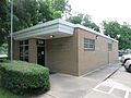 US post office is located on Arthur Street.
 -
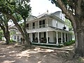 Bucksnag Hunting Club is in a grand old house.
 -
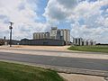 Silos can be seen on Texas 71 across from the school.
 -
 Garwood Elementary School (Rice CISD) on Texas 71


References
- ^ U.S. Geological Survey Geographic Names Information System: Garwood, Texas
- ^ a b Garwood, Texas from the Handbook of Texas Online
- ^ a b "Garwood, Texas". Texas Escapes Online Magazine. Retrieved October 22, 2009.
- ^ USPS – Cities by ZIP Code
- ^ "Decennial Census by Decade". US Census Bureau.
- ^ "1900 Census of Population - Population of Texas By Counties And Minor Civil Divisions" (PDF). United States Census Bureau.
- ^ "1910 Census of Population - Supplement for Texas" (PDF). United States Census Bureau.
- ^ "1920 Census of Population - Number of Inhabitants - Texas" (PDF). United States Census Bureau.
- ^ "1930 Census of Population - Number of Inhabitants - Texas" (PDF). United States Census Bureau.
- ^ "1940 Census of Population - Number of Inhabitants - Texas" (PDF). United States Census Bureau.
- ^ "1950 Census of Population - Number of Inhabitants - Texas" (PDF). United States Census Bureau.
- ^ "1960 Census of Population - Number of Inhabitants - Texas" (PDF). United States Census Bureau.
- ^ "1970 Census of Population - Number of Inhabitants - Texas" (PDF). United States Census Bureau.
- ^ "1980 Census of Population - Number of Inhabitants - Texas" (PDF). United States Census Bureau.
- ^ "1990 Census of Population - Population and Housing Unit Counts - Texas" (PDF). United States Census Bureau.
- ^ "2000 Census of Population - Population and Housing Unit Counts - Texas" (PDF). United States Census Bureau.
- ^ a b "2010 Census of Population - Population and Housing Unit Counts - Texas" (PDF). United States Census Bureau.
- ^ a b "P2: Hispanic or Latino, and Not Hispanic or Latino by Race – 2020: DEC Redistricting Data (PL 94-171) – Garwood CDP, Texas". United States Census Bureau.
- ^ Climate Summary for Garwood, Texas
- ^ Texas Education Code Sec. 130.211. WHARTON COUNTY JUNIOR COLLEGE DISTRICT SERVICE AREA.
Municipalities and communities of Colorado County, Texas, United States | ||
|---|---|---|
| Cities |  | |
| CDPs | ||
| Other communities | ||
| Ghost towns | ||
- Pages using gadget WikiMiniAtlas
- Use mdy dates from July 2023
- Articles with short description
- Short description is different from Wikidata
- Pages using infobox settlement with bad settlement type
- Coordinates on Wikidata
- Unincorporated communities in Colorado County, Texas
- Unincorporated communities in Texas