Frontón, Ciales, Puerto Rico
Frontón | |
|---|---|
Barrio | |
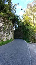
.jpg) Puerto Rico Highway 146 in Frontón barrio | |
 Location of Frontón within the municipality of Ciales shown in red | |
 Frontón Location of Puerto Rico | |
| Coordinates: 18°18′30″N 66°33′31″W / 18.308335°N 66.558693°W[1] | |
| Commonwealth | |
| Municipality | |
| Area | |
| • Total | 11.42 sq mi (29.6 km2) |
| • Land | 11.42 sq mi (29.6 km2) |
| • Water | 0 sq mi (0 km2) |
| Elevation | 1,129 ft (344 m) |
| Population (2010) | |
| • Total | 2,228 |
| • Density | 195.1/sq mi (75.3/km2) |
| Source: 2010 Census | |
| Time zone | UTC−4 (AST) |
Frontón is a barrio in the municipality of Ciales, Puerto Rico. Its population in 2010 was 2,228.[3][4][5]
Economy
Walmart in Puerto Rico works with USDA-approved businesses located in Frontón, such as Lettufresh, which supply fresh lettuce to Walmart and Amigo Supermarkets.[6]
History
Frontón was in Spain's gazetteers[7] until Puerto Rico was ceded by Spain in the aftermath of the Spanish–American War under the terms of the Treaty of Paris of 1898 and became an unincorporated territory of the United States. In 1899, the United States Department of War conducted a census of Puerto Rico finding that the population of Frontón barrio was 3,706.[8]
Frontón saw a 38.9% increase in population from 1990 to 2000 then a 17.0% decrease from 2000 to 2010.
| Census | Pop. | Note | %± |
|---|---|---|---|
| 1900 | 3,706 | — | |
| 1910 | 3,367 | −9.1% | |
| 1920 | 4,095 | 21.6% | |
| 1930 | 3,355 | −18.1% | |
| 1940 | 3,977 | 18.5% | |
| 1950 | 2,518 | −36.7% | |
| 1960 | 2,634 | 4.6% | |
| 1970 | 1,902 | −27.8% | |
| 1980 | 1,883 | −1.0% | |
| 1990 | 1,933 | 2.7% | |
| 2000 | 2,684 | 38.9% | |
| 2010 | 2,228 | −17.0% | |
| U.S. Decennial Census 1899 (shown as 1900)[9] 1910-1930[10] 1930-1950[11] 1980-2000[12] 2010[13] | |||
Sectors
Barrios (which are, in contemporary times, roughly comparable to minor civil divisions)[14] in turn are further subdivided into smaller local populated place areas/units called sectores (sectors in English). The types of sectores may vary, from normally sector to urbanización to reparto to barriada to residencial, among others.[15][16][17]
The following sectors are in Frontón barrio:[18]
Comunidad Ana Rosario, Comunidad El Perico, Comunidad Juan Pino, Comunidad Los Burgos, Comunidad Los González, Comunidad Quique Pagan, Comunidad San Virón, Parcelas Seguí Nueva, Parcelas Seguí Vieja, Comunidad Sumidero, Sector Atrecho, Sector Garau, Sector La Aldea, Sector Limón, Sector Raynes, Sector Sabana, and Sector Yunes.
Gallery
-
 Puerto Rico Highway 140 in Frontón
 -
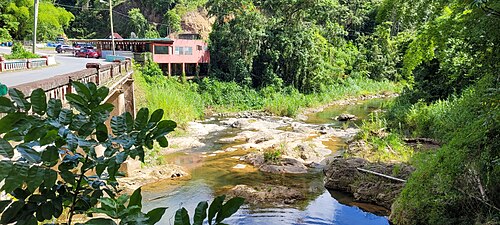 Yunes River between Frontón (Ciales) and Mameyes Abajo (Utuado) barrios


See also
References
- ^ a b "US Gazetteer 2019". US Census. US Government.
- ^ U.S. Geological Survey Geographic Names Information System: Frontón barrio
- ^ Picó, Rafael; Buitrago de Santiago, Zayda; Berrios, Hector H. Nueva geografía de Puerto Rico: física, económica, y social, por Rafael Picó. Con la colaboración de Zayda Buitrago de Santiago y Héctor H. Berrios. San Juan Editorial Universitaria, Universidad de Puerto Rico,1969.
- ^ Gwillim Law (20 May 2015). Administrative Subdivisions of Countries: A Comprehensive World Reference, 1900 through 1998. McFarland. p. 300. ISBN 978-1-4766-0447-3. Retrieved 25 December 2018.
- ^ Puerto Rico: 2010 Population and Housing Unit Counts.pdf (PDF). U.S. Dept. of Commerce, Economics and Statistics Administration, U.S. Census Bureau. 2010.
- ^ "Walmart expands in-stores supply of lettuce harvested in Puerto Rico". News is My Business. 4 October 2021. Retrieved 30 January 2023.
- ^ "Anuario del comercio, de la industria, de la magistratura y de la administración. 1881". Biblioteca Nacional de España (in Spanish). p. 1614. Retrieved 4 April 2023.
- ^ Joseph Prentiss Sanger; Henry Gannett; Walter Francis Willcox (1900). Informe sobre el censo de Puerto Rico, 1899, United States. War Dept. Porto Rico Census Office (in Spanish). Imprenta del gobierno. p. 161.
- ^ "Report of the Census of Porto Rico 1899". War Department Office Director Census of Porto Rico. Archived from the original on July 16, 2017. Retrieved September 21, 2017.
- ^ "Table 3-Population of Municipalities: 1930 1920 and 1910" (PDF). United States Census Bureau. Archived (PDF) from the original on August 17, 2017. Retrieved September 21, 2017.
- ^ "Table 4-Area and Population of Municipalities Urban and Rural: 1930 to 1950" (PDF). United States Census Bureau. Archived (PDF) from the original on August 30, 2015. Retrieved September 21, 2014.
- ^ "Table 2 Population and Housing Units: 1960 to 2000" (PDF). United States Census Bureau. Archived (PDF) from the original on July 24, 2017. Retrieved September 21, 2017.
- ^ Puerto Rico: 2010 Population and Housing Unit Counts.pdf (PDF). U.S. Dept. of Commerce Economics and Statistics Administration U.S. Census Bureau. 2010. Archived (PDF) from the original on 2017-02-20. Retrieved 2019-08-02.
- ^ "US Census Barrio-Pueblo definition". factfinder.com. US Census. Archived from the original on 13 May 2017. Retrieved 5 January 2019.
- ^ "Agencia: Oficina del Coordinador General para el Financiamiento Socioeconómico y la Autogestión (Proposed 2016 Budget)". Puerto Rico Budgets (in Spanish). Retrieved 28 June 2019.
- ^ Rivera Quintero, Marcia (2014), El vuelo de la esperanza: Proyecto de las Comunidades Especiales Puerto Rico, 1997-2004 (first ed.), San Juan, Puerto Rico Fundación Sila M. Calderón, ISBN 978-0-9820806-1-0
- ^ "Leyes del 2001". Lex Juris Puerto Rico (in Spanish). Retrieved 24 June 2020.
- ^ "DESGLOSE DE SECTORES Y CENTROS DE VOTACIÓN CIALES 023" (PDF). Comisión Estatal de Elecciones Puerto Rico (in Spanish). 19 October 2018. Archived from the original (PDF) on 15 June 2020. Retrieved 15 June 2020.
External links
This Ciales, Puerto Rico location article is a stub. You can help Wikipedia by expanding it. |
- Pages using gadget WikiMiniAtlas
- CS1 Spanish-language sources (es)
- Articles with short description
- Short description is different from Wikidata
- Short description matches Wikidata
- Coordinates on Wikidata
- Articles containing Spanish-language text
- Barrios of Ciales, Puerto Rico
- All stub articles
- Puerto Rico senatorial district III geography stubs