Fionn Loch (Suilven)
| Fionn Loch | |
|---|---|
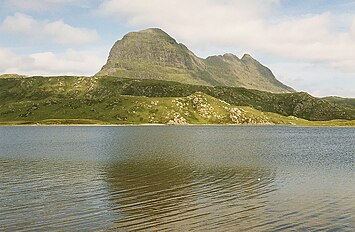
 Suilven reflected on Fionn Loch | |
 Fionn Loch Location in Sutherland | |
| Location | NC13041741 |
| Coordinates | 58°06′23″N 5°10′23″W / 58.106291°N 5.173018°W |
| Type | freshwater loch |
| Primary inflows | Uidh Fhearna from Loch Veyatie |
| Primary outflows | River Kirkaig |
| Max. length | 4.00 km (2.49 mi)[1] |
| Max. width | 0.48 km (0.30 mi)[1] |
| Surface area | 83 ha (210 acres)[2] |
| Average depth | 20.34 ft (6.20 m)[1] |
| Max. depth | 89.89 ft (27.40 m)[1] |
| Water volume | 182,731,116.7 cu ft (5,174,369.00 m3)[1] |
| Shore length1 | 12 km (7.5 mi) [2] |
| Surface elevation | 114 m (374 ft)[2] |
| Max. temperature | 53 °F (12 °C) |
| 1 Shore length is not a well-defined measure. | |
Fionn Loch is a small irregular-shaped shallow freshwater loch, on a north-west to south-east orientation that is located 3 miles southeast of Lochinver[1][2][3] in the Assynt district of Sutherland in Scotland. The loch is located in an area known as the Assynt-Coigach National Scenic Area,[4] one of 40 such areas in Scotland.[5]
Geography
Fionn Loch is part of the Fionn Loch drainage system and is fed with water from River Ledbeg which drains Loch Urigill, due south-by-south east and Loch Borralan, to the east of Urigill.[6] Loch Veyatie directly south, drains through Uidh Fheàrna, a slow-moving channel into Fionn Loch.[6] The drainage system was once a large lake, Loch Suilven that is now made up of Cam Loch, Veyatie and Fionn Loch.[6] A vast number of lochs and lochans surround Fionn Loch, the biggest is the large irregular-shaped Loch Sionascaig along with Inverpolly Forest directly south.
Overlooking the loch to the north-west is the imposing hulk of the mountains of Suilven at 731 meters.[7] Almost directly south of the loch is Cùl Mòr at 849m and Drumrunie Forest. To the far north-west is Drumrunie Forest.
Walking
Fionn Loch is remote and can be reached from a route that starts from Inverkirkaig, this route reaches the bealach from the south, passing Kirkaig Falls on the way.[8]
Gallery
- Images of Fionn Loch
-
 Fionn Loch looking towards Suilven.
 -
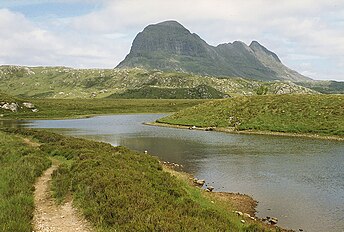
 Fionn Loch and Suilven Fionn Loch and the prominent hill of Suilven lie south east of the coastal village of Lochinver in the Assynt area
 -
 The start of the River Kirkaig The outflow from Fionn Loch where the River Kirkaig commences. Suilven can be seen in the distance.
 -
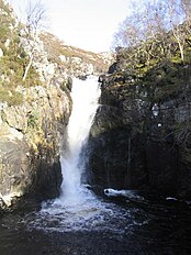 Falls of Kirkaig


References
- ^ a b c d e f John, Murray; Lawrence, Pullar. Bathymetrical Survey of the Fresh-Water Lochs of Scotland, 1897–1909 Lochs of the Kirkaig Basin Volume II – Fionn Loch. p. 166. Retrieved 31 March 2022.
 This article incorporates text from this source, which is in the public domain.
- ^ a b c d "Fionn Loch". Centre for Ecology and Hydrology. Scotland and Northern Ireland Forum for Environmental Research (SNIFFER). Archived from the original on 11 June 2016. Retrieved 31 March 2022.
- ^ Gittings, Bruce; Munro, David. "Fionn Loch". The Gazetteer for Scotland. School of GeoSciences, University of Edinburgh and The Royal Scottish Geographical Society. Retrieved 31 March 2022.
- ^ "Assynt-Coigach National Scenic Area". NatureScot. Retrieved 2 October 2020.
- ^ "National Scenic Areas". NatureScot. Retrieved 2 October 2020.
- ^ a b c Yu, G.; Harrison, S.P. (May 1995). Lake Status Records From Europe: Data base Documentation. Paleoclimatology Publications Series Report No.3. Boulder, Colorado: NOAA Paleoclimatology Program. p. 262.
- ^ "Amazing Images Explore Scotland's Great Wilderness". National Geographic. National Geographic Partners, LLC. 16 December 2020. Retrieved 8 May 2022.
- ^ "Walk of the week: Falls of Kirkaig and Fionn Loch, Sutherland". JPIMedia. The Scotsman. 19 June 2009. Retrieved 8 May 2022.
- Pages using gadget WikiMiniAtlas
- Source attribution
- Use dmy dates from March 2022
- Use British English from March 2022
- Articles with short description
- Short description is different from Wikidata
- Pages using infobox body of water with auto short description
- Articles with OS grid coordinates
- Coordinates on Wikidata
- Articles using infobox body of water without alt
- Articles using infobox body of water without pushpin map alt
- Articles using infobox body of water without image bathymetry
- Freshwater lochs of Scotland
- Kirkaig Basin
- Sites of Special Scientific Interest in Scotland