File:Historic American Buildings Survey Nathaniel R. Ewan, Photographer April 5, 1937 EXTERIOR - WEST ELEVATION - Weart-Hunt House, Stoutsburg-Amwell Road, Hopewell, Mercer County, NJ HABS NJ,11-HOP.V,1-1.tif
Jump to navigation
Jump to search

Size of this JPG preview of this TIF file: 800 × 548 pixels. Other resolutions: 320 × 219 pixels | 640 × 439 pixels | 1,024 × 702 pixels | 1,280 × 877 pixels | 2,560 × 1,754 pixels | 4,768 × 3,267 pixels.
Original file (4,768 × 3,267 pixels, file size: 14.86 MB, MIME type: image/tiff)
Summary
| Historic American Buildings Survey Nathaniel R. Ewan, Photographer April 5, 1937 EXTERIOR - WEST ELEVATION - Weart-Hunt House, Stoutsburg-Amwell Road, Hopewell, Mercer County, NJ | ||||
|---|---|---|---|---|
| Title |
Historic American Buildings Survey Nathaniel R. Ewan, Photographer April 5, 1937 EXTERIOR - WEST ELEVATION - Weart-Hunt House, Stoutsburg-Amwell Road, Hopewell, Mercer County, NJ |
|||
| Depicted place | New Jersey; Mercer County; Hopewell | |||
| Dimensions | 5 x 7 in. | |||
| Current location |
Library of Congress Prints and Photographs Division Washington, D.C. 20540 USA http://hdl.loc.gov/loc.pnp/pp.print |
|||
| Accession number |
HABS NJ,11-HOP.V,1-1 |
|||
| Credit line |
|
|||
| Source | https://www.loc.gov/pictures/item/nj0552.photos.107439p | |||
| Permission (Reusing this file) |
|
|||

File history
Click on a date/time to view the file as it appeared at that time.
| Date/Time | Thumbnail | Dimensions | User | Comment | |
|---|---|---|---|---|---|
| current | 20:03, 23 February 2023 | 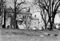 | 4,768 × 3,267 (14.86 MB) | commons>Zeete | Cropped 5 % horizontally, 9 % vertically using CropTool with precise mode. |
File usage
There are no pages that use this file.