File:Aspen trees along the high dirt road leading to Crested Butte, Colorado, from the distant Crystal River Valley LCCN2015633794.tif
Original file (8,688 × 5,792 pixels, file size: 287.97 MB, MIME type: image/tiff)
This file is from a shared repository and may be used by other projects. The description on its file description page there is shown below.
Summary
DescriptionAspen trees along the high dirt road leading to Crested Butte, Colorado, from the distant Crystal River Valley LCCN2015633794.tif |
English: Title: Aspen trees along the high dirt road leading to Crested Butte, Colorado, from the distant Crystal River Valley
Physical description: 1 photograph : digital, tiff file, color. Notes: Purchase; Carol M. Highsmith Photography, Inc.; 2015; (DLC/PP-2015:068).; Forms part of: Gates Frontiers Fund Colorado Collection within the Carol M. Highsmith Archive.; Credit line: Gates Frontiers Fund Colorado Collection within the Carol M. Highsmith Archive, Library of Congress, Prints and Photographs Division.; Title, date and keywords based on information provided by the photographer. |
||||||||||||||||||||||||||
Date | Taken on 10 August 2015, 16:29 (according to Exif data) | ||||||||||||||||||||||||||
Source |
Library of Congress
|
||||||||||||||||||||||||||
Author |
creator QS:P170,Q5044454 |
||||||||||||||||||||||||||
Permission (Reusing this file) |
No known restrictions on publication.
|
Camera location | 38° 54′ 06.01″ N, 107° 13′ 23.62″ W | View this and other nearby images on: OpenStreetMap | 38.901670; -107.223227 |
---|
Licensing
Public domainPublic domainfalsefalse |
This work is from the Carol M. Highsmith Archive collection at the Library of Congress. According to the library, there are no known copyright restrictions on the use of this work. Carol M. Highsmith has stipulated that her photographs are in the public domain. Photographs of sculpture or other works of art may be restricted by the copyright of the artist. |
Items portrayed in this file
depicts
2015
38°54'6.012"N, 107°13'23.617"W
image/tiff
7dedb27ecc7b9ad02af73f941edcf3a201dbc14c
301,962,630 byte
5,792 pixel
8,688 pixel
File history
Click on a date/time to view the file as it appeared at that time.
Date/Time | Thumbnail | Dimensions | User | Comment | |
---|---|---|---|---|---|
current | 02:03, 2 October 2016 | 
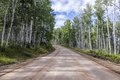
8,688 × 5,792 (287.97 MB) | commons>Fæ | LOC 2015633794, Carol M. Highsmith collection. P406.24045 TIFF (288.0mb) |
File usage
There are no pages that use this file.
Metadata
This file contains additional information, probably added from the digital camera or scanner used to create or digitize it.
If the file has been modified from its original state, some details may not fully reflect the modified file.
Image title | Aspen trees along the high dirt road leading to Crested Butte, Colorado, from the distant Crystal River Valley. |
---|---|
Camera manufacturer | Canon |
Camera model | Canon EOS 5DS R |
Author | Carol M. Highsmith |
Copyright holder | Carol M Highsmith |
Exposure time | 1/60 sec (0.016666666666667) |
F Number | f/10 |
ISO speed rating | 100 |
Date and time of data generation | 16:29, 10 August 2015 |
Lens focal length | 24 mm |
Latitude | 38° 54′ 6.01″ N |
Longitude | 107° 13′ 23.62″ W |
Altitude | 2,695.2 meters above sea level |
Width | 8,688 px |
Height | 5,792 px |
Bits per component |
|
Compression scheme | Uncompressed |
Pixel composition | RGB |
Image data location | 34,926 |
Orientation | Normal |
Number of components | 3 |
Number of rows per strip | 5,792 |
Bytes per compressed strip | 301,925,376 |
Horizontal resolution | 300 dpi |
Vertical resolution | 300 dpi |
Data arrangement | chunky format |
Software used | Adobe Photoshop CC 2015 (Macintosh) |
File change date and time | 00:07, 11 August 2015 |
Exposure Program | Manual |
Exif version | 2.3 |
Date and time of digitizing | 16:29, 10 August 2015 |
APEX shutter speed | 5.906891 |
APEX aperture | 6.643856 |
APEX exposure bias | 0 |
Maximum land aperture | 4 APEX (f/4) |
Metering mode | Pattern |
Flash | Flash did not fire |
DateTimeOriginal subseconds | 56 |
Color space | Uncalibrated |
Focal plane X resolution | 2,413.3333435059 |
Focal plane Y resolution | 2,413.3333435059 |
Focal plane resolution unit | 3 |
Custom image processing | Normal process |
Exposure mode | Manual exposure |
White balance | Auto white balance |
Scene capture type | Standard |
GPS time (atomic clock) | 21:29 |
Satellites used for measurement | 9 |
Receiver status | Measurement in progress |
Measurement mode | 3-dimensional measurement |
Measurement precision | Excellent (1.6) |
Reference for direction of image | Magnetic direction |
Direction of image | 319 |
Geodetic survey data used | WGS-84 |
GPS date | 10 August 2015 |
GPS tag version | 0.0.3.2 |