Fentons Creek, Victoria
Jump to navigation
Jump to search
| Fentons Creek Victoria | |
|---|---|
 The church at Fentons Creek | |
 Fentons Creek | |
| Coordinates | 36°33′33″S 143°32′21″E / 36.55917°S 143.53917°E |
| Population | 115 (2006 census)[1] |
| Postcode(s) | 3518 |
| Elevation | 250 m (820 ft) |
| Location |
|
| LGA(s) | Shire of Loddon |
| State electorate(s) | Ripon |
| Federal division(s) | Mallee |
Fentons Creek is a locality in Victoria, Australia. It is located near Wedderburn in the Loddon Shire. A creek with the same name runs along the edge of the township. At the 2006 census, the suburb had a population of 115.[1]

The town covers a large area. At a central spot there is a Country Fire Authority station/shed, a chapel and an old schoolhouse that is no longer used.
Gallery
-
 The chapel
 -
 The old schoolhouse
 -
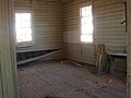 Inside the schoolhouse


References
Wikimedia Commons has media related to Fentons Creek, Victoria.
- ^ a b Australian Bureau of Statistics (25 October 2007). "Fentons Creek (State Suburb)". 2006 Census QuickStats. Retrieved 27 January 2009.
This article about a location in the Mallee is a stub. You can help Wikipedia by expanding it. |
Categories:
- Pages using gadget WikiMiniAtlas
- Use Australian English from August 2019
- All Wikipedia articles written in Australian English
- Use dmy dates from July 2019
- Articles with short description
- Short description matches Wikidata
- Coordinates on Wikidata
- Towns in Victoria (state)
- Commons category link from Wikidata
- Shire of Loddon
- Mining towns in Victoria (state)
- All stub articles
- Mallee geography stubs