Füzér
Jump to navigation
Jump to search
Füzér | |
|---|---|
 | |
 Seal | |
 Füzér Location of Füzér | |
| Coordinates: 48°32′20″N 21°27′19″E / 48.53880°N 21.45517°E | |
| Country | |
| County | Borsod-Abaúj-Zemplén |
| Area | |
| • Total | 37.53 km2 (14.49 sq mi) |
| Population (2004) | |
| • Total | 585 |
| • Density | 15.58/km2 (40.4/sq mi) |
| Time zone | UTC+1 (CET) |
| • Summer (DST) | UTC+2 (CEST) |
| Postal code | 3996 |
| Area code | 47 |
Füzér is a village in Borsod-Abaúj-Zemplén county, Hungary. It contains the northernmost point of Hungary. The castle of Füzér is located in this village.
Picture gallery
-

-

-
-

-

-
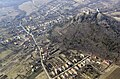
 Aerial photograph: Füzér - castle
 -
 Füzér Castle in March 2024


External links
- Street map (in Hungarian)
- Aerial photographs of the Castle
- Images, history and google map of the Castle


| International | |
|---|---|
| National | |
This article about a castle in Hungary is a stub. You can help Wikipedia by expanding it. |
This Borsod-Abaúj-Zemplén location article is a stub. You can help Wikipedia by expanding it. |
Categories:
- Articles with short description
- Short description is different from Wikidata
- Coordinates on Wikidata
- Pages using infobox settlement with unknown parameters
- Articles with Hungarian-language sources (hu)
- Articles with VIAF identifiers
- Articles with J9U identifiers
- Articles with LCCN identifiers
- Articles with NKC identifiers
- Populated places in Borsod-Abaúj-Zemplén County
- Castles in Hungary
- All stub articles
- Hungarian building and structure stubs
- European castle stubs
- Borsod-Abaúj-Zemplén geography stubs