Espírito Santo do Pinhal
Jump to navigation
Jump to search
This article needs additional citations for verification. (December 2009) |
Espírito Santo do Pinhal | |
|---|---|
| Municipality of Espírito Santo do Pinhal | |
| Nickname: Pinhal | |
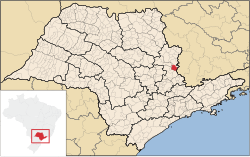
 Location in São Paulo | |
| Coordinates: 22°11′27″S 46°44′27″W / 22.19083°S 46.74083°W | |
| Country | |
| Region | Southeast |
| State | |
| Founded | December 27, 1849 |
| Government | |
| • Mayor | Sérgio del Bianchi Junior (2017 - 2020) (PSD) |
| Area | |
| • Total | 389 km2 (150 sq mi) |
| Elevation | 870 m (2,850 ft) |
| Population (2020)[1] | |
| • Total | 44,471 |
| • Density | 110/km2 (300/sq mi) |
| Time zone | UTC−3 (BRT) |
| HDI (2010) | 0.787 – high[2] |
| Website | www |
Espírito Santo do Pinhal (Portuguese meaning "Holy Spirit of Pinhal") is a municipality in the state of São Paulo in Brazil. The population in 2020 is 44,471 (IBGE 2020)[3] and the area is 389 km2. The elevation is 870 m.
Media
In telecommunications, the city was served by Telecomunicações de São Paulo.[4] In July 1998, this company was acquired by Telefónica, which adopted the Vivo brand in 2012. The company is currently an operator of cell phones, fixed lines, internet (fiber optics/4G) and television (satellite and cable).[5]
Notable people
References
- ^ IBGE 2020
- ^ "Archived copy" (PDF). United Nations Development Programme (UNDP). Archived from the original (PDF) on July 8, 2014. Retrieved August 1, 2013.
{{cite web}}: CS1 maint: archived copy as title (link) - ^ "IBGE - @Cidades".
- ^ "Creation of Telesp - April 12, 1973". www.imprensaoficial.com.br (in Portuguese). Retrieved 2024-06-04.
- ^ "Our History - Telefônica RI". Telefônica. Retrieved 2024-06-04.
![]() Media related to Espírito Santo do Pinhal at Wikimedia Commons
Media related to Espírito Santo do Pinhal at Wikimedia Commons
Categories:
- Pages using gadget WikiMiniAtlas
- CS1 maint: archived copy as title
- CS1 Portuguese-language sources (pt)
- Articles with short description
- Short description matches Wikidata
- Articles needing additional references from December 2009
- All articles needing additional references
- Short description is different from Wikidata
- Pages using multiple image with auto scaled images
- Coordinates on Wikidata
- Commons category link from Wikidata
- Municipalities in São Paulo (state)
- All stub articles
- São Paulo (state) geography stubs


