Elmhurst, Victoria
| Elmhurst Victoria | |
|---|---|
 General store | |
 Elmhurst | |
| Coordinates | 37°11′0″S 143°15′0″E / 37.18333°S 143.25000°E |
| Population | 185 (2021 census)[1] |
| Postcode(s) | 3469 |
| Location | |
| LGA(s) | Rural City of Ararat |
| State electorate(s) | Ripon |
| Federal division(s) | |
Elmhurst is a town in the Pyrenees region of western Victoria, Australia. The town is on the Pyrenees Highway between Eversley and Amphitheatre. Elmhurst is in the Rural City of Ararat local government area, 191 kilometres (119 mi) north-west of the state capital, Melbourne. The headwaters of the Wimmera River form near Elmhurst. At the 2021 census, Elmhurst had a population of 185.[1]
Mount Cole and the Mount Buangor State Park are located south of Elmhurst.
The general store is now closed. Elmhurst has a small post office that is open limited hours Monday-Friday (9 am - 1 pm).
The Elmhurst Recreation Reserve (on Green st) has public toilets, a picnic area and a playground.
Gallery
-
 Elmhurst Mechanics Institute
 -
 Anglican Church
 -
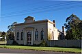 Bank Building
 -
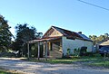 Butcher Shop
 -
 Elmhurst Hotel
 -
 Elmhurst Pyrenees Highway
 -
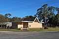 Uniting Church


References
- ^ a b Australian Bureau of Statistics (28 June 2022). "Elmhurst". 2021 Census QuickStats. Retrieved 16 November 2022.
External links
![]() Media related to Elmhurst, Victoria at Wikimedia Commons
Media related to Elmhurst, Victoria at Wikimedia Commons
Localities in the Rural City of Ararat | ||
|---|---|---|
| Town | | |
| Locality |
| |
^ - Territory divided with another LGA | ||
This article about a location in Victoria, Australia is a stub. You can help Wikipedia by expanding it. |
- Australian Statistical Geography Standard 2021 ID same as Wikidata
- Use Australian English from August 2019
- All Wikipedia articles written in Australian English
- Use dmy dates from July 2019
- Articles with short description
- Short description matches Wikidata
- Coordinates on Wikidata
- Towns in Victoria (state)
- Commons category link from Wikidata
- All stub articles
- Victoria (state) geography stubs