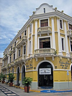
Edificio Oliver
Edificio Oliver | |
 Edificio Oliver in 2009 | |
| Location | 64 Calle José de Diego Arecibo, Puerto Rico |
|---|---|
| Coordinates | 18°28′21″N 66°42′55″W / 18.472584°N 66.715239°W |
| Built | 1914 |
| Architectural style | Beaux Arts |
| NRHP reference No. | 86002764[1] |
| Added to NRHP | October 1, 1986 |
Edificio Oliver in Arecibo, Puerto Rico was built in 1914. The building houses government offices for the municipality of Arecibo.
A Beaux Arts-style building, it was the first building made of reinforced concrete in the Arecibo area.[2]
It is located in the town center on the location of the former "King's House", the military garrison building built by the Spanish government in 1765. After 1868 that building became a courthouse, a police headquarters, and a public school then was demolished in 1913. The Edificio Oliver was built soon after in the corner location and was used both as a residence and for commercial purposes. It served also served as a foreign consulate.[2]
Edificio Oliver was listed on the National Register of Historic Places in 1986.[1]
References
- ^ a b "National Register Information System". National Register of Historic Places. National Park Service. March 13, 2009.
- ^ a b Felix Julian del Campo and Hector Santiago (July 1986). "National Register of Historic Places Inventory/Nomination: Edificio Oliver". National Park Service. with five photos from 1986
- Articles using NRISref without a reference number
- Articles with short description
- Short description is different from Wikidata
- Coordinates on Wikidata
- Articles containing Spanish-language text
- Government buildings on the National Register of Historic Places in Puerto Rico
- Beaux-Arts architecture in Puerto Rico
- Government buildings completed in 1914
- National Register of Historic Places in Arecibo, Puerto Rico
- 1914 establishments in Puerto Rico
- All stub articles
- Puerto Rico Registered Historic Place stubs
- Puerto Rican building and structure stubs
