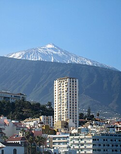
Edificio Bel Air
Jump to navigation
Jump to search
| Edificio Bel Air | |
|---|---|
 | |
 | |
| General information | |
| Type | Residential |
| Location | Puerto de la Cruz, Spain |
| Completed | 1960 |
| Height | 75 metres (246 ft) |
The Bel Air Building is a skyscraper in the town of Puerto de la Cruz, Tenerife, Canary Islands, Spain. Completed in 1960, it has 26 floors and rises up to 75 metres (246 ft).[1] It is the fourth tallest building on the island of Tenerife, after the twin Santa Cruz Towers and Tres de Mayo Avenue Skyscraper, both in Santa Cruz, the island's capital.
Built in 1960,[2] it began as a hotel of American innovation. Twenty years later it became private residential apartments.[1]
See also
References
- ^ a b "Edificio Bel Air I". Emporis. Emporis GMBH. Archived from the original on December 15, 2013. Retrieved 11 August 2013.
- ^ Edificio Belair, Expediente, Redac 16
28°24′53″N 16°32′52″W / 28.4148°N 16.5479°W
Categories:
- Articles with short description
- Short description is different from Wikidata
- Infobox mapframe without OSM relation ID on Wikidata
- Coordinates on Wikidata
- Puerto de la Cruz
- Residential buildings completed in 1960
- Buildings and structures in Tenerife
- Residential skyscrapers in Spain
- Companies of the Canary Islands
- All stub articles
- Spanish building and structure stubs
- Pages using the Kartographer extension