Duranbah, New South Wales
Jump to navigation
Jump to search
| Duranbah New South Wales | |||||||||||||||
|---|---|---|---|---|---|---|---|---|---|---|---|---|---|---|---|
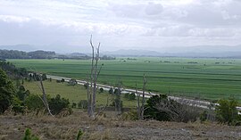
 Pacific Motorway and Tweed Valley viewed from Duranbah | |||||||||||||||
| Coordinates | 28°18′18″S 153°31′21″E / 28.30500°S 153.52250°E | ||||||||||||||
| Population | 262 (2011 census)[1] | ||||||||||||||
| Elevation | 65 m (213 ft) | ||||||||||||||
| Time zone | AEST (UTC+10) | ||||||||||||||
| • Summer (DST) | AEDT (UTC+11) | ||||||||||||||
| Location |
| ||||||||||||||
| LGA(s) | Tweed Shire | ||||||||||||||
| State electorate(s) | Tweed | ||||||||||||||
| Federal division(s) | Richmond | ||||||||||||||
| |||||||||||||||
Duranbah is a town located in north-eastern New South Wales, Australia, in the Tweed Shire.
Demographics
In the 2011 census, Duranbah recorded a population of 262 people, 50.4% female and 49.6% male.
The median age of the Duranbah population was 36 years, 1 year below the national median of 37.
85.2% of people living in Duranbah were born in Australia. The other top responses for country of birth were England 3.8%, New Zealand 2.3%, Scotland 1.1%, United States of America 1.1%, Indonesia 1.1%.
95% of people spoke only English at home.
References
- ^ Australian Bureau of Statistics (31 October 2012). "Duranbah (State Suburb)". 2011 Census QuickStats. Retrieved 20 January 2014.
Categories:
- Australian Statistical Geography Standard 2011 ID same as Wikidata
- Articles with short description
- Short description matches Wikidata
- Use Australian English from February 2017
- All Wikipedia articles written in Australian English
- Use dmy dates from July 2023
- Coordinates on Wikidata
- Towns in New South Wales
- Suburbs of Tweed Heads, New South Wales
- All stub articles
- Northern Rivers geography stubs
