Draft:Tropical cyclones in 1976
| Draft article not currently submitted for review.
This is a draft Articles for creation (AfC) submission. It is not currently pending review. While there are no deadlines, abandoned drafts may be deleted after six months. To edit the draft click on the "Edit" tab at the top of the window. To be accepted, a draft should:
It is strongly discouraged to write about yourself, your business or employer. If you do so, you must declare it. Where to get help
How to improve a draft
You can also browse Wikipedia:Featured articles and Wikipedia:Good articles to find examples of Wikipedia's best writing on topics similar to your proposed article. Improving your odds of a speedy review To improve your odds of a faster review, tag your draft with relevant WikiProject tags using the button below. This will let reviewers know a new draft has been submitted in their area of interest. For instance, if you wrote about a female astronomer, you would want to add the Biography, Astronomy, and Women scientists tags. Editor resources
Last edited by Auric (talk | contribs) 56 days ago. (Update) |
During 1976, tropical cyclones formed in seven major bodies of water, commonly known as tropical cyclone basins. Tropical cyclones were named by various weather agencies when they attained maximum sustained winds of 35 knots (65 km/h; 40 mph). During the year, 137 tropical cyclones formed.
Summary
North Atlantic Ocean

The season officially begun on June 1, however the first system (an unnamed subtropical storm) would form on May 21. The system would bring beneficial rainfall to Florida before transitioning into an extratropical low on May 25.[1] After the season officially begun, two tropical depressions would form in June. The first system would form near the Bahamas on June 7 and dissipate two days later, while the second one would produce light rainfall for Southern Florida before dissipating near Bermuda.[2] In July, three systems would form, but only one of them, Anna, would be named. Anna would develop from an extratropical low on July 28, but would dissipate a few days later, later affecting the Azores with gale-force winds as an extratropical cyclone.[2][3]

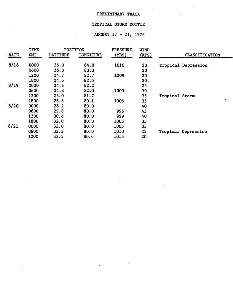
In August, five systems would form with all of them being named: Belle, Dottie, Candice, Emmy, and Frances. Belle would form on August 6, peak as a minimal major hurricane, and impact the East Coast with gale-force winds before dissipating four days later.[2] Dottie would form eight days after Belle dissipated, later impacting portions of the Southeast as a minimal tropical storm before dissipating a few days later.[4] Candice, Emmy, and Frances would stay out to sea throughout their lifetime, however, Frances would undergo a Fujiwhara interaction with Emmy before the latter got absorbed by the former on September 4.
In September, six systems would form, however, only one system, Gloria, would be named. As Emmy was absorbed by Frances, a tropical depression formed off the coast of the Carolinas. The depression moved parallel to the coast but would dissipate halfway between Cape Hatteras and Bermuda two days later. The next depression developed over the eastern Gulf of Mexico on September 5 and would dissipate near the mouth of the Mississippi River two days later. An unnamed subtropical storm would form on September 13, dissipating in the Southeastern United States four days later. Another depression formed near the Cape Verde Islands on September 20. Moving generally northwestward for several days, the depression would dissipate over the central Atlantic. A tropical depression would form in the Gulf of Mexico on September 22. Tracking northward, the depression made landfall in southeastern Louisiana with winds of 30 mph (45 km/h) late on September 24 and would later dissipating over Mississippi. Gloria would develop in the open Atlantic on September 26 but would dissipate a few days later without affecting land. As Gloria was forming, another tropical depression would form. Failing to intensify significantly, the depression dissipated two days later.[2]
In October, three systems would form, but only one, Holly, would be named. A tropical depression classified as Tropical Depression Ten formed between the coast of Africa and the Lesser Antilles on October 3.[5] Initially trekking west-northwestward for a few days, it would turn southwestward on October 5. The depression crossed the Lesser Antilles early on October 8, passing between Saint Lucia and Saint Vincent. Continuing westward over the Caribbean, the storm slowly curved northward by the next day. Early on October 12, the depression made landfall near Barahona, Dominican Republic, with winds of 30 mph (45 km/h). Later that day, it would dissipated near Luperón.[2] The depression would bring heavy rainfall to parts of Puerto Rico, with a peak of 8.04 in (204 mm) near Guayama.[5] Another tropical depression would form between Puerto Rico and the western coast of Africa on October 12, but would dissipate over the central Atlantic three days later.[2] The last system, Holly, would form on October 22, and would dissipate a few days later. No tropical cyclones would form in November, making the season end thirty-nine days early. [2]
East & Central Pacific Ocean

The season would begin on May 15 in the East Pacific and June 1 in the Central Pacific, however the first system, a weak tropical depression would form in the East Pacific on June 2. The depression would dissipate a few days later.[6] The day after the depression formed, the season's first named storm, Annette, would develop offshore Mexico. Annette would peak as a Category 4 hurricane but would not affect land before dissipating on June 14.[6][7] After Annette dissipated, two extra systems would form in June: Bonny and Four. Bonny would peak as a minimum hurricane and not affect land, while Four would peak as a tropical depression and affect Oaxaca before dissipating.[6][7]
In June, four systems would form, with all of them being named: Celeste, Diana, Estelle, and Fernanda. Neither of these storms would impact land, but Diana would peak as a Category 2 hurricane.[6][7] In August, six systems would form, but only four of them would be named: Gwen, Hyacinth, Iva, and Joanne. All of the storms would stay out to sea, but Hyacinth and Iva would peak as major hurricanes.[6][7]
September would be notable, due to hurricanes Kathleen, Liza, and Madeline. Kathleen would be notable due to being one of the only tropical cyclones to impact the Southeastern United States with gale-force winds,[8] Liza would be notable due to being one of the worst natural disasters in the history of Baja California Sur,[9] while Madeline would be one of the most powerful storms to make landfall in the East Pacific basin. As well as those storms, Hurricane Kate would form in the Central Pacific basin.[10][11] Kate would leave only minimal damages to Hawaii before dissipating on October 2.[12] Only one system would form in October: Naomi. Peaking as a minimal tropical storm, Naomi would impact Mexico before dissipating on October 29.[7] After Naomi dissipated, no other storm would form, making the season ending prematurely.
Systems
May
May would feature one system which went unnamed. In the North Atlantic, a subtropical storm would impact Florida.
| Storm name | Dates active | Max wind
km/h (mph) |
Pressure
(hPa) |
Areas affected | Damage
(USD) |
Deaths | Refs |
|---|---|---|---|---|---|---|---|
| One | May 21 – 25 | 85 (50) | 994 | Florida | $628,000 | None | [13] |
June
June would feature six systems, with two of them being named. In the East Pacific, an unnamed tropical depression would impact the state of Oaxaca, mainly producing heavy rainfall before dissipating.[6] In the North Atlantic, another unnamed tropical depression would bring heavy rainfall to Florida.[8]
| Storm name | Dates active | Max wind
km/h (mph) |
Pressure
(hPa) |
Areas affected | Damage
(USD) |
Deaths | Refs |
|---|---|---|---|---|---|---|---|
| TD | June 2 – 3 | 60 (35) | Unknown | None | None | None | |
| Annette | June 3 – 14 | 220 (140) | 925 | None | None | None | |
| TD | June 7 – 9 | 60 (35) | Unknown | None | None | None | |
| TD | June 11 – 12 | 60 (35) | Unknown | Florida | None | None | |
| Bonny | June 26 – 29 | 120 (75) | 987 | None | None | None | |
| TD | June 28 – 30 | 60 (35) | Unknown | Oaxaca | None | None |
References
- ^ Elwyn E. Wilson, ed. (November 1976). "Marine Weather Review: Principal Tracks of Centers of Cyclones at Sea Level, North Atlantic May 1976". Mariners Weather Log. 20 (6). Washington, D.C.: National Oceanic and Atmospheric Administration, Environmental Data Service: 354.
- ^ a b c d e f g "Atlantic hurricane best track (HURDAT version 2)" (Database). United States National Hurricane Center. April 5, 2023. Retrieved June 14, 2024.
 This article incorporates text from this source, which is in the public domain.
- ^ Miles B. Lawrence (April 1977). "Atlantic Hurricane Season of 1976: Subtropical storm no. 1, 21-25 May". Monthly Weather Review. 105 (4): 499–500. Bibcode:1977MWRv..105..497L. doi:10.1175/1520-0493(1977)105<0497:AHSO>2.0.CO;2. Retrieved September 28, 2021.
- ^ Paul J. Hebert. Preliminary Track: Tropical Storm Dottie – August 17-21, 1976 (Report). National Hurricane Center. p. 1-3. Retrieved January 26, 2019.
- ^ a b David M. Roth (2015). "Tropical Depression Ten - October 8-13, 1976". Weather Prediction Center. National Oceanic and Atmospheric Administration. Retrieved June 17, 2015.
- ^ a b c d e f Emil L. Gunther (April 1977). "Eastern North Pacific Tropical Cyclones of 1976". Monthly Weather Review (PDF). 105 (4). American Meteorological Society: 508–522. Bibcode:1977MWRv..105..508G. doi:10.1175/1520-0493(1977)105<0508:EPTCO>2.0.CO;2.
- ^ a b c d e National Hurricane Center; Hurricane Research Division; Central Pacific Hurricane Center (April 26, 2024). "The Northeast and North Central Pacific hurricane database 1949–2023". United States National Oceanic and Atmospheric Administration's National Weather Service. Archived from the original on May 29, 2024. A guide on how to read the database is available here. This article incorporates text from this source, which is in the public domain.
- ^ a b "Annoying Weather Predicted". The Palm Beach Post. June 12, 1976. p. 50. Retrieved October 13, 2018 – via Newspapers.com.

- ^ John Seaman; Sally Leivesley; C. Hogg (1984). Epidemiology of Natural Disasters. ISBN 9783805537797.
- ^ Pao-Shin Chu; Peng Wu (2008). Climatic Atlas of Tropical Cyclone Tracks over the Central North Pacific (PDF) (Report). University of Hawaii-Manoa. Retrieved August 2, 2015.
- ^ Central Pacific Hurricane Center archive accessed March 11, 2006
- ^ Central Pacific Hurricane Center archive accessed March 11, 2006
- ^ "Storm Data and Unusual Weather Phenomena" (PDF). Storm Data. 18 (5). May 1976. ISSN 0039-1972. Archived from the original (PDF) on May 11, 2021. Retrieved May 11, 2021.