Dodman Island
Jump to navigation
Jump to search

Dodman Island is an island 6.5 km (4.0 mi) long, lying 7.4 km (4.6 mi) south-east of Rabot Island and 18.5 km (11.5 mi) west of Ferin Head, off the west coast of Graham Land, Antarctica. The island was charted and named by the British Graham Land Expedition, 1934–37, under John Rymill.[1]
Important Bird Area
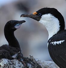
A small (12 ha) island lying about 2.5 km to the north of Dodman has been identified as an Important Bird Area (IBA) by BirdLife International because it supports a breeding colony of Antarctic shags, with 163 pairs recorded there in 1984.[2]
See also
References
- ^ "Dodman Island". Geographic Names Information System. United States Geological Survey, United States Department of the Interior. Retrieved 22 January 2012.
- ^ "Island north of Dodman Island". BirdLife data zone: Important Bird Areas. BirdLife International. 2013. Archived from the original on 10 July 2007. Retrieved 7 January 2013.
![]() This article incorporates public domain material from "Dodman Island". Geographic Names Information System. United States Geological Survey.
This article incorporates public domain material from "Dodman Island". Geographic Names Information System. United States Geological Survey.
65°58′S 65°46′W / 65.967°S 65.767°W
Categories:
- Articles with short description
- Short description matches Wikidata
- Use dmy dates from April 2022
- Wikipedia articles incorporating text from the USGS Geographic Names Information System
- Coordinates on Wikidata
- Important Bird Areas of Antarctica
- Seabird colonies
- Islands of Graham Land
- Graham Coast
- All stub articles
- Graham Coast geography stubs