Cudell, Cleveland
Cudell | |
|---|---|
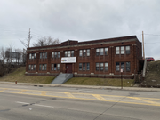
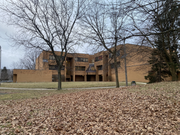
 West Technical High School building in Cudell | |
 | |
| Coordinates: 41°28′23″N 81°45′25″W / 41.473°N 81.757°W | |
| Country | United States |
| State | Ohio |
| County | Cuyahoga County |
| City | Cleveland |
| Population | |
| • Total | 9,960 |
| Demographics[1] | |
| • White | 46.8% |
| • Black | 32.3% |
| • Hispanic (of any race) | 21.3% |
| • Asian and Pacific Islander | 3.5% |
| • Mixed and Other | 17.4% |
| Time zone | UTC-5 (EST) |
| • Summer (DST) | UTC-4 (EDT) |
| Area code | 216 |
| Median income[1] | $26,425 |
| Source: 2020 U.S. Census | |
Cudell is a neighborhood on the West Side of Cleveland, Ohio. Named after Frank E. Cudell, the neighborhood has been a part of Cleveland since 1904, upon the completion of municipal annexation of the land by the city.[2]
For Cleveland City Council, the Cudell neighborhood is split between the 11th[3] and 15th[4] wards, and is represented jointly by council members Danny Kelly and Jenny Spencer.
History
Cudell is located on land which was originally the property of Franklin Reuben Elliott, a horticulturalist and fruit farmer.[5][6] The land changed ownership multiple times before being purchased by Frank E. Cudell, an architect whose firm designed multiple buildings in Cleveland, including apartment buildings on W. 99th St.[7]
Cudell also deeded a portion of land along West Blvd. to the city which was used as a public park and eventually became home to Cudell Recreation Center. Today, the Cudell Tower, a memorial to Cudell from his wife, stands on the site of Cudell’s estate near the recreation center in an area known as Cudell Commons.[8][9]
Throughout the 20th century, Cudell was a working class neighborhood populated by workers from nearby factories.[10][11] Cudell’s population peaked at roughly 17,600 in 1940.[12] In the 1960s, Interstate 90 was constructed, isolating the southern portion of the neighborhood.[13][14]
In 2014, Cudell Recreation Center was the site of the shooting of Tamir Rice.[15]
Demographics
As of 2021, Cudell had a population of 9,960.[1] Cudell is a racially diverse neighborhood. As of 2021, the population was 46.8% white, 32.3% black, 3.5% Asian-American/Pacific Islander, and 17.4% other races, with 21.3% of the population self-reporting as hispanic or latino.[1]
40.9% of Cudell’s population, 50.4% of Cudell’s child population, and 31.7% of Cudell’s senior population live below the poverty line.[1]
The majority of Cudell’s population resides in one- or two-family homes, with the exception of a concentration of apartments near the RTA Rapid Transit's West Boulevard–Cudell station.[16][17]
Gallery
-
 The B. Riley House, a substance abuse treatment facility for LGBTQ+ adults located on W. 117th St. in Cudell.
 -
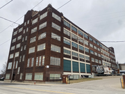 The Dorn Color Inc. building, located on Berea Rd. in Cudell.
 -
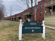 Boulevard Terrace, an apartment complex located near the West Boulevard-Cudell Station.
 -
 The Cudell Recreation Center, the site of the shooting of Tamir Rice.
 -
 The West Boulevard-Cudell station, which provides RTA Rapid Transit service to the neighborhood and is located at the intersection of Detroit Ave. and West Blvd. in Cudell.
 -
 Cudell Tower, a monument to Frank E. Cudell located in Cudell Commons.
 -
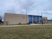
 Marion C. Seltzer Elementary School, located in Cudell Commons.
 -
 Cleveland Fire Station no. 23, located on Madison Ave. in Cudell.


References
- ^ a b c d e f "Cleveland Neighborhoods and Wards: Cudell Neighborhood Factsheet (2021)" (PDF). The Center for Community Solutions (Cleveland). Retrieved 5 February 2024.
- ^ Roy, Christopher (9 May 2019). "CUDELL". Encyclopedia of Cleveland History | Case Western Reserve University. Case Western Reserve University. Retrieved 5 February 2024.
- ^ "Brian Mooney - Ward 11". clevelandcitycouncil.org. Cleveland City Council. Retrieved 1 May 2020.
- ^ "Jenny Spencer - Ward 15". clevelandcitycouncil.org. Cleveland City Council. Retrieved 1 July 2021.
- ^ Roy, Christopher (9 May 2019). "CUDELL". Encyclopedia of Cleveland History | Case Western Reserve University. Case Western Reserve University. Retrieved 5 February 2024.
- ^ "ELLIOTT, FRANKLIN REUBEN". Encyclopedia of Cleveland History. Case Western Reserve University. Retrieved 5 February 2024.
- ^ Roy, Christopher (9 May 2019). "CUDELL". Encyclopedia of Cleveland History | Case Western Reserve University. Case Western Reserve University. Retrieved 5 February 2024.
- ^ Roy, Christopher (9 May 2019). "CUDELL". Encyclopedia of Cleveland History | Case Western Reserve University. Case Western Reserve University. Retrieved 5 February 2024.
- ^ "District 1: Cudell". Cleveland City Planning Commission. Cleveland City Planning Commission. Retrieved 5 February 2024.
- ^ Roy, Christopher (9 May 2019). "CUDELL". Encyclopedia of Cleveland History | Case Western Reserve University. Case Western Reserve University. Retrieved 5 February 2024.
- ^ "District 1: Cudell". Cleveland City Planning Commission. Cleveland City Planning Commission. Retrieved 5 February 2024.
- ^ Roy, Christopher (9 May 2019). "CUDELL". Encyclopedia of Cleveland History | Case Western Reserve University. Case Western Reserve University. Retrieved 5 February 2024.
- ^ Roy, Christopher (9 May 2019). "CUDELL". Encyclopedia of Cleveland History | Case Western Reserve University. Case Western Reserve University. Retrieved 5 February 2024.
- ^ "District 1: Cudell". Cleveland City Planning Commission. Cleveland City Planning Commission. Retrieved 5 February 2024.
- ^ Izadi, Elahe; Holley, Peter (November 26, 2014). "Video shows Cleveland officer shooting 12-year-old Tamir Rice within seconds". The Washington Post. Archived from the original on January 1, 2016. Retrieved 5 February 2024.
- ^ Roy, Christopher (9 May 2019). "CUDELL". Encyclopedia of Cleveland History | Case Western Reserve University. Case Western Reserve University. Retrieved 5 February 2024.
- ^ "District 1: Cudell". Cleveland City Planning Commission. Cleveland City Planning Commission. Retrieved 5 February 2024.
External links
Places adjacent to Cudell, Cleveland | |
|---|---|
This Cuyahoga County, Ohio state location article is a stub. You can help Wikipedia by expanding it. |