Cima delle Pozzette
Jump to navigation
Jump to search
This article needs additional citations for verification. (February 2024) |
| Cima delle Pozzette | |
|---|---|
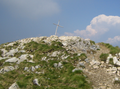
 Cima delle Pozzette summit with view to the south to Cima Valdritta | |
| Highest point | |
| Elevation | 2,132 m (6,995 ft) |
| Coordinates | 45°44′04″N 10°50′59″E / 45.734583°N 10.849671°E |
| Geography | |
 Cima delle Pozzette Italy | |
| Location | Veneto, northern Italy |
| Parent range | Alps, Brescia and Garda Prealps |
| Climbing | |
| Easiest route | rock/snow climb |
Cima delle Pozzette is one of the highest summits of the Monte Baldo mountain range and thereby part of the Garda Mountains in northern Italy.[1]
Morphology
Cima delle Pozzette is one of the highest peaks of the Monte Baldo range, that roughly extends from north to south. Other prominent peaks in the range are Punta Telegrafo and Cima Valdritta to the south.
Access
The summit can be reached from the south via Punta Telegrafo passing Cima Valdritta as a long hike over the Monte Baldo mountain ridge, or easiest from north from the summit station of the cable car from Malcesine.
-
 Cross at summit.

References
- ^ "Cima delle Pozzette". Lo Scarpone (in Italian). 14 September 2023. Retrieved 29 February 2024.
External links
![]() Media related to Cima delle Pozzette at Wikimedia Commons
Media related to Cima delle Pozzette at Wikimedia Commons
Categories:
- Pages using gadget WikiMiniAtlas
- CS1 Italian-language sources (it)
- Articles with short description
- Short description matches Wikidata
- Use dmy dates from February 2024
- Articles needing additional references from February 2024
- All articles needing additional references
- Coordinates on Wikidata
- Commons category link from Wikidata
- Mountains of the Alps
- Mountains of Veneto
- Mountains of Trentino
- Garda Mountains
- Two-thousanders of Italy