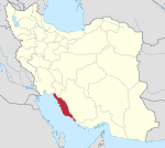
Chah-e Mobarak Rural District
Jump to navigation
Jump to search
Chah-e Mobarak Rural District
Persian: دهستان چاه مبارک | |
|---|---|
| Coordinates: 27°22′45″N 52°49′53″E / 27.37917°N 52.83139°E[1] | |
| Country | Iran |
| Province | Bushehr |
| County | Asaluyeh |
| District | Chah-e Mobarak |
| Capital | Chah-e Mobarak |
| Population (2016)[2] | |
| • Total | 12,078 |
| Time zone | UTC+3:30 (IRST) |
Chah-e Mobarak Rural District (Persian: دهستان چاه مبارک) is in Chah-e Mobarak District of Asaluyeh County, Bushehr province, Iran. It is administered from the city of Chah-e Mobarak.[3]
After the 2011 census, Asaluyeh District was separated from Kangan County in the establishment of Asaluyeh County, which was divided into two districts of two rural districts each, with the city of Asaluyeh as its capital.[3]
At the most recent census of 2016, the population of the rural district was 12,078 in 2,974 households. The most populous of its 15 villages was Chah-e Mobarak (now a city),[4] with 4,968 people.[2]
References
- ^ OpenStreetMap contributors (29 March 2023). "Chah-e Mobarak Rural District (Asaluyeh County)" (Map). OpenStreetMap. Retrieved 29 March 2023.
- ^ a b "Census of the Islamic Republic of Iran, 1395 (2016)". AMAR (in Persian). The Statistical Center of Iran. p. 18. Archived from the original (Excel) on 3 August 2017. Retrieved 19 December 2022.
- ^ a b Rahimi, Mohammad Reza (29 September 2013). "Approval letter regarding country divisions in Bushehr province". Islamic Parliament Research Center of the Islamic Republic of Iran (in Persian). Ministry of Interior. Archived from the original on 10 January 2013. Retrieved 29 March 2023.
- ^ "In Asaluyeh County, Chah-e Mobarak Municipality was opened". Mehr News (in Persian). 21 March 2016. Archived from the original on 6 November 2023. Retrieved 6 November 2023.
Categories:
- CS1 Persian-language sources (fa)
- Articles with short description
- Short description is different from Wikidata
- Use dmy dates from January 2023
- Short description matches Wikidata
- Articles containing Persian-language text
- Coordinates on Wikidata
- Rural Districts of Bushehr Province
- Populated places in Asaluyeh County
- All stub articles
- Bushehr Province geography stubs

