Cellettes, Charente
Jump to navigation
Jump to search
Cellettes | |
|---|---|
 Town hall | |
Location of Cellettes  | |
 Cellettes  Cellettes | |
| Coordinates: 45°51′52″N 0°08′54″E / 45.8644°N 0.1483°E | |
| Country | France |
| Region | Nouvelle-Aquitaine |
| Department | Charente |
| Arrondissement | Confolens |
| Canton | Boixe-et-Manslois |
| Intercommunality | Cœur de Charente |
| Government | |
| • Mayor (2020–2026) | Norbert Aguesseau[1] |
| Area 1 | 9.37 km2 (3.62 sq mi) |
| Population (2021)[2] | 382 |
| • Density | 41/km2 (110/sq mi) |
| Time zone | UTC+01:00 (CET) |
| • Summer (DST) | UTC+02:00 (CEST) |
| INSEE/Postal code | 16069 /16230 |
| Elevation | 52–117 m (171–384 ft) (avg. 105 m or 344 ft) |
| 1 French Land Register data, which excludes lakes, ponds, glaciers > 1 km2 (0.386 sq mi or 247 acres) and river estuaries. | |
Cellettes (French pronunciation: [selɛt]) is a commune in the Charente department, Southwestern France.
Population
| Year | Pop. | ±% p.a. |
|---|---|---|
| 1968 | 259 | — |
| 1975 | 222 | −2.18% |
| 1982 | 294 | +4.09% |
| 1990 | 346 | +2.06% |
| 1999 | 415 | +2.04% |
| 2009 | 440 | +0.59% |
| 2014 | 429 | −0.51% |
| 2020 | 385 | −1.79% |
| Source: INSEE[3] | ||
Gallery
-
 Forêt de Boixe in winter
 -
 Dolmen also wrongly said as a "sacrifice table", is located in the Forêt de Boixe
 -
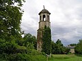 Chapel of the Château d'Échoisy


See also
References
- ^ "Répertoire national des élus: les maires". data.gouv.fr, Plateforme ouverte des données publiques françaises (in French). 9 August 2021.
- ^ "Populations légales 2021" (in French). The National Institute of Statistics and Economic Studies. 28 December 2023.
- ^ Population en historique depuis 1968, INSEE
Wikimedia Commons has media related to Cellettes (Charente).
| Authority control databases: National |
|---|
This Charente geographical article is a stub. You can help Wikipedia by expanding it. |
Categories:
- Pages using gadget WikiMiniAtlas
- CS1 French-language sources (fr)
- Use dmy dates from August 2023
- Articles with short description
- Short description is different from Wikidata
- Coordinates on Wikidata
- Pages using infobox settlement with image map1 but not image map
- Pages with French IPA
- Commons category link is on Wikidata
- Articles with BNF identifiers
- Articles with BNFdata identifiers
- Communes of Charente
- All stub articles
- Charente geography stubs
- Pages using the Kartographer extension