Cape Leeuwin Lighthouse
 Cape Leeuwin Lighthouse | |
 | |
| Location | Cape Leeuwin Western Australia |
|---|---|
| Coordinates | 34°22′27″S 115°08′09″E / 34.37417°S 115.13583°E |
| Tower | |
| Construction | limestone tower |
| Height | 39 metres (128 ft) |
| Shape | cylindrical tower on square base |
| Markings | white tower and lantern |
| Heritage | listed on the Commonwealth Heritage List, State Registered Place |
| Light | |
| First lit | 1895 |
| Focal height | 57 metres (187 ft) |
| Lens | 2nd order Chance Brothers Fresnel lens[1] |
| Characteristic | Fl W 7.5s. |
| Official name | Cape Leeuwin Lighthouse |
| Type | Listed place (Historic) |
| Designated | 22 June 2004 |
| Reference no. | 105416 |
| Type | State Registered Place |
| Designated | 13 May 2005 |
| Reference no. | 104 |
The Cape Leeuwin Lighthouse is a lighthouse located on the headland of Cape Leeuwin, /ˈluːwɪn/ ⓘ the most south-westerly point on the mainland of the Australian Continent, in the state of Western Australia.
Cape Leeuwin Lighthouse was constructed by a company led by M. C. Davies, with George Temple Poole supervising the construction of the light and designing the keepers' quarters.[2] The light tower which is built of local stone was originally designed to show two lights – a higher white light and a lower red light. Although the foundations were completed, the lower light was never installed.[3] It was opened with great ceremony in 1895 by John Forrest, the Premier of Western Australia. Until June 1982 the lens was rotated by a counter weight driving clockwork mechanism, and the beacon was a pressure kerosene mantle type. A radio navigation beacon was commissioned in 1955 and operated until 1992.[3] The lighthouse was automated in 1982.[2] The lighthouse, besides being a navigational aid, serves as an important automatic weather station. The lighthouse's buildings and grounds are now vested in the local tourism body and the single (1960s) and double (1980s) communications towers that were north-west of the lighthouse, seen in older photographs of Cape Leeuwin, have been removed.
The nearest functioning lighthouse north of Cape Leeuwin is the much smaller Cape Hamelin lighthouse, just south of the Hamelin Bay camping area.
The young Felix von Luckner, later a German World War I war hero, noted for his long voyage on the Seeadler during which he captured 14 enemy ships, was briefly assistant lighthouse keeper. He abandoned the job when discovered with his hotel-keeper's daughter by her father.
International Lighthouse Day was celebrated at Cape Leeuwin lighthouse for the first time in 2004.[4] The climb to the viewing deck consists of 176 steps.[3]
Picture gallery
-
 Cape Leeuwin and lighthouse as seen from the north
 -
 Cape Leeuwin seen from the east
 -
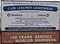 Sign at Cape Leeuwin Lighthouse.
 -
 Lighthouse and cottages, Cape Leeuwin
 -
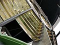 The Fresnel lens in Cape Leeuwin lighthouse


See also
References
- ^ Rowlett, Russ. "Lighthouses of Australia: Western Australia". The Lighthouse Directory. University of North Carolina at Chapel Hill. Retrieved 21 July 2008.
- ^ a b "Cape Leeuwin Lighthouse and Quarters". Heritage Council of Western Australia. Retrieved 2 August 2019.
- ^ a b c "History - Cape Leeuwin Lighthouse". Margaret River Attractions. Retrieved 20 June 2020.
- ^ Lighthouses of Australia Inc. "Bulletin No 5/2004 - Sept/October 2004". Archived from the original on 4 March 2009.
External links
- "Cape Leeuwin Lighthouse". Lighthouses of Western Australia. Lighthouses of Australia Inc.
- Cape Leeuwin Lighthouse tour information Archived 18 December 2012 at the Wayback Machine
- - List of WA lighthouses - check link to Cape Leeuwin
| Authority control databases: Geographic |
|---|
- Pages using the Phonos extension
- Use dmy dates from December 2020
- Use Australian English from August 2011
- All Wikipedia articles written in Australian English
- Articles with short description
- Short description is different from Wikidata
- Infobox mapframe without OSM relation ID on Wikidata
- Coordinates on Wikidata
- All articles using infobox lighthouse
- Pages including recorded pronunciations
- Commons category link is on Wikidata
- Webarchive template wayback links
- Articles with admiralty identifiers
- Articles with ARLHS identifiers
- Articles with NGA identifiers
- Lighthouses completed in 1895
- Lighthouses in Western Australia
- Museums in Western Australia
- Lighthouse museums in Australia
- 1895 establishments in Australia
- Commonwealth Heritage List places in Western Australia
- Cape Leeuwin, Western Australia
- Heritage-listed lighthouses in Australia
- State Register of Heritage Places in the Shire of Augusta-Margaret River
- Pages using the Kartographer extension