Calvin, Kentucky
Jump to navigation
Jump to search
Calvin, Kentucky | |
|---|---|
 Calvin  Calvin | |
| Coordinates: 36°43′20″N 83°37′20″W / 36.72222°N 83.62222°W | |
| Country | United States |
| State | Kentucky |
| County | Bell |
| Elevation | 1,079 ft (329 m) |
| Time zone | UTC-5 (Eastern (EST)) |
| • Summer (DST) | UTC-4 (EDT) |
| ZIP code | 40813 |
| Area code | 606 |
| GNIS feature ID | 488650[1] |
Calvin is an unincorporated community in Bell County, Kentucky, United States.[1] The community is located along U.S. Route 119 and the Cumberland River 4.9 miles (7.9 km) southeast of Pineville. The area on the south side of the river is also known as Page, which was the name of the Louisville and Nashville Railroad station in the community.[2] Calvin has a post office with ZIP code 40813, which opened on April 3, 1908.[3][4]
References
- ^ a b "Calvin". Geographic Names Information System. United States Geological Survey, United States Department of the Interior.
- ^ "Kentucky Hometown Locator". Retrieved June 6, 2018.
- ^ United States Postal Service. "USPS - Look Up a ZIP Code". Retrieved April 9, 2017.
- ^ "Postmaster Finder - Post Offices by ZIP Code". United States Postal Service. Archived from the original on October 17, 2020. Retrieved April 9, 2017.
Municipalities and communities of Bell County, Kentucky, United States | ||
|---|---|---|
| Cities | 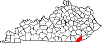 | |
| CDP | ||
| Other unincorporated communities |
| |
| post offices (and the creeks they are on) |
| |
| Ghost towns | ||
| Footnotes | ‡This populated place also has portions in an adjacent county or counties | |
This Bell County, Kentucky state location article is a stub. You can help Wikipedia by expanding it. |
Categories:
- Pages using gadget WikiMiniAtlas
- Articles with short description
- Short description is different from Wikidata
- Use mdy dates from July 2023
- Coordinates on Wikidata
- Unincorporated communities in Bell County, Kentucky
- Unincorporated communities in Kentucky
- All stub articles
- Bell County, Kentucky geography stubs