Bnehran
Jump to navigation
Jump to search
Bnehran
بنهران | |
|---|---|
Village | |
| Coordinates: 34°16′25″N 35°51′06″E / 34.27361°N 35.85167°E | |
| Country | |
| Governorate | North Governorate |
| District | Koura District |
| Time zone | UTC+2 (EET) |
| • Summer (DST) | UTC+3 (EEST) |
| Dialing code | +961 |
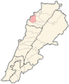
Bnehran is a Muslim village in Koura District of Lebanon.[1] It is 570 metres above sea level and has an area of 2.7 square kilometres (1.05 sq mi). It has 50 households and 566 residents.[2]
References
- ^ "Municipal and ikhtiyariah elections in Northern Lebanon" (PDF). The Monthly. March 2010. p. 23. Archived from the original on 3 June 2016. Retrieved 2 November 2016.
{{cite web}}: CS1 maint: bot: original URL status unknown (link) - ^ Baldati.com Archived July 24, 2011, at the Wayback Machine
Categories:
- Pages using gadget WikiMiniAtlas
- CS1 maint: bot: original URL status unknown
- Webarchive template wayback links
- Articles with short description
- Short description is different from Wikidata
- Coordinates on Wikidata
- Populated places in the North Governorate
- Koura District
- Shia Muslim communities in Lebanon
- All stub articles
- Lebanon geography stubs

