Bakka, Aurland
Bakka | |
|---|---|
Village | |
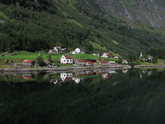
 View from the fjord | |
 Bakka Location of the village  Bakka Bakka (Norway) | |
| Coordinates: 60°54′59″N 6°52′08″E / 60.9163°N 6.8689°E | |
| Country | Norway |
| Region | Western Norway |
| County | Vestland |
| District | Sogn |
| Municipality | Aurland Municipality |
| Elevation | 18 m (59 ft) |
| Time zone | UTC+01:00 (CET) |
| • Summer (DST) | UTC+02:00 (CEST) |
| Post Code | 5749 Bakka |
Bakka is a tiny village in Aurland Municipality in Vestland county, Norway. It is located on the western shore of the Nærøyfjord, about 5 kilometres (3.1 mi) north of the village of Gudvangen and access to the European route E16 highway. The village is home to the Bakka Church. In 2000, the 1.7-kilometre (1.1 mi) Bakka Tunnel was constructed on the road from Gudvangen to Bakka to make the journey quicker and safer.
Name
The name Bakka is derived from the Old Norse word bakki which means "(river) bank". The -a ending is the dative case ending used with prepositions to show location: "on the bank".[citation needed] In the 19th century, it was common to spell the name Bakke.[2]
Media gallery
-
 View of Bakka
 -
 Bakka
Bakka -
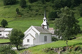 Bakka Church
 -
 Village and church
 -
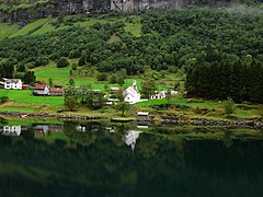
 Overview of Bakka and Nærøyfjord


References
- ^ "Bakka, Aurland (Vestland)". yr.no. Retrieved 25 January 2020.
- ^ Rygh, Oluf (1919). Norske gaardnavne: Nordre Bergenhus amt (in Norwegian) (12 ed.). Kristiania, Norge: W. C. Fabritius & sønners bogtrikkeri. p. 122.
This Vestland location article is a stub. You can help Wikipedia by expanding it. |
- Pages using gadget WikiMiniAtlas
- CS1 Norwegian-language sources (no)
- Use dmy dates from August 2018
- Articles with short description
- Short description is different from Wikidata
- Coordinates on Wikidata
- All articles with unsourced statements
- Articles with unsourced statements from September 2021
- Villages in Vestland
- Aurland
- All stub articles
- Vestland geography stubs