Avenida Las Américas
| Bulevar Luis A. Ferré | |
.jpg) | |
| Native name | Avenida Las Américas (Spanish) |
|---|---|
| Former name(s) | Avenida Interior |
| Part of | PR-163 |
| Namesake | Luis A. Ferré |
| Owner | Ponce Municipal Government |
| Maintained by | DTOP and Ponce Municipal Government |
| Length | 7.0 km |
| Width | 6 lanes |
| Location | From Canas to Canas Urbano to San Antón |
| East end | Barrio Canas at PR-500 |
| Major junctions |
|
| West end | Barrio San Antón at PR-1 and Avenida Emilio Fagot |
| Construction | |
| Commissioned | 1960[1]: 52 |
| Construction start | 1955 |
| Completion | 1960[1]: 52 |
| Inauguration | 1 January 1960 |
| Other | |
| Known for | Major West–East artery |
| Status | In use |
Avenida Las Américas, is a major thoroughfare in Ponce, Puerto Rico. Most of its length is signed as Puerto Rico Highway 163 (PR-163). The highway has both of its termini as well as all of its length entirely within the Ponce city limits. It runs west to east. As of 12 November 2010, the segment of this road from its intersection in the west with PR-2R (a.k.a., Carretera Pámpanos) to its intersection in the east with PR-12, officially became the Bulevar Luis A. Ferré.[2] The segment from Avenida Hostos in the east to Carretera Pámpanos (PR-2R) in the west, the first segment built, was built in 1960.[1]: 52
Route description
The highway is a two-way divided six-lane road that starts at its junction in Barrio Canas with PR-500, near Avenida Baramaya (PR-9), next to Puente San Antonio,[1]: 251 and runs east until it meets PR-1 at Bulevar Miguel Pou.
Avenida Las Américas runs easterly from PR-500, intersecting with Ramal PR-2 (PR-2R) near Francisco Montaner Stadium and Juan Pachín Vicéns Auditorium, and passing Secretaría de Recreación y Deportes. Continuing east it passes Pontifical Catholic University of Puerto Rico,[3] and Museo de Arte de Ponce,[4] before intersecting with Avenida Hostos (PR-123). Other points of interest on Avenida Las Américas[5] are the former Puerto Rico Police headquarters for the Ponce Region, the Ponce Governmental Center, and Hospital Metropolitano Dr. Pila. Continuing east, the road crosses Rio Portugués and immediately afterwards the road intersects Avenida Santiago de los Caballeros (PR 12), and takes a northerly turn to intersect with PR-1 at Bulevar Miguel Pou, about one mile further. Additional businesses along its way are Café Rico and Centro del Sur Mall, both at Avenida Las Américas's intersection with PR-133, also known as Calle Comercio.
-
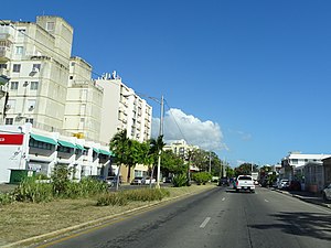
 Hospital Metropolitano Dr. Pila on the north side of Avenida Las Américas looking northeast, in Barrio Canas Urbano
 -
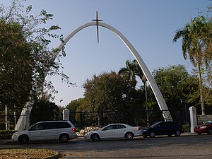 Main entrance to the Pontifical Catholic University of Puerto Rico at Avenida Las Américas
_looking_NE_in_Barrio_Canas_Urbano,_Ponce,_Puerto_Rico_(IMG_2739).jpg)
.jpg)
Characteristics
Avenida Las Américas is 7.0 kilometers long and ends at the intersection of Boulevard Miguel Pou (PR-1). Although Avenida Las Américas ends at its intersection with PR-1, physically the roadway continues as a non-divided four-lane road called Avenida Emilio Fagot to intersect with PR-14 and, further north, to come to an end at a junction with PR-10 for access to points in northeast and north Puerto Rico, respectively. The less transited western section of Avenida Las Américas experiences an hourly traffic flow upwards of 2400 vehicles.[6] On the westernmost end of the road, Puente San Antonio connects Avenida Las Américas with PR-9, also called Avenida Baramaya.[1]: 251
-
 Avenida Las Américas eastbound
 -
 Avenida Las Américas sign
.jpg)
_y_Av._Eduardo_Rubert%C3%A9_(PR-585),_Bo._Canas_Urbano,_Ponce,_PR_(DSC04251).jpg)
History
The segment of Avenida Las Américas from Avenida Hostos in the east to Carretera Pámpanos (PR-2R) in the west, was the first segment built; it was built in 1960.[1]: 52 In the 1960s, the segment from Carretera Pámpanos in the east to just before PR-500 in the west was built as part of the urban development of that area in the 1960s. However, Avenida Las Américas came to an abrupt dead end before reaching PR-500. The third segment built was built to connect Avenida Las Américas from Avenida Hostos (PR-123) in the west to Avenida Julio E. Monagas in the east. This last segment was built in the 1980s. During the same period the road was expanded to the west to connect Avenida Las Américas with PR-500.
See also
References
- ^ a b c d e f g Carmelo Rosario Natal. Ponce En Su Historia Moderna: 1945-2002. Published by Secretaría de Cultura y Turismo of the Government of the Autonomous Municipality of Ponce. Ponce, Puerto Rico. 2003.
- ^ Rolón Romero, Ana María (10–17 November 2010). "Bautizan el Bulevar Luis Alberto Ferré". Periódico La Perla del Sur (in Spanish). Ponce, Puerto Rico.
- ^ Rodríguez Grafal, Jason (5 March 2010). "La Escuela de Arquitectura: Coquetea con la Internacionalización". Periodico La Perla: El Periodico de Ponce y la Region Sur de Puerto Rico. (in Spanish) (Electronic ed.). Ponce, Puerto Rico. Noticia Locales section. Retrieved 5 March 2010.
- ^ "Exceptional Works at Ponce Museum of Art". Puerto Rico Channel. NewMedia Holdings. Archived from the original on 22 February 2018. Retrieved 16 June 2012.
- ^ "Museo de Arte de Ponce Location on PR-163". Archived from the original on 21 August 2007. Retrieved 19 November 2009.
- ^ "Repavimentarán tramo de la Avenida Las Américas en Ponce". El Sur a la Vista. Ponce, Puerto Rico. 12 July 2011. Retrieved 13 July 2011.
External links
- Historia de las Carreteras de Puerto Rico. (in Spanish)
- Domenech, Manuel Victor (April 1919). "Roads in Porto Rico". The Overland Monthly. 73 (4): 321.