Athenry railway station
Jump to navigation
Jump to search
Athenry Baile Átha an Rí | |||||||||||||||||||||||||||||||
|---|---|---|---|---|---|---|---|---|---|---|---|---|---|---|---|---|---|---|---|---|---|---|---|---|---|---|---|---|---|---|---|
 Platform at Athenry | |||||||||||||||||||||||||||||||
| General information | |||||||||||||||||||||||||||||||
| Location | Church Street Athenry, County Galway Ireland | ||||||||||||||||||||||||||||||
| Coordinates | 53°18′3″N 8°44′59″W / 53.30083°N 8.74972°W | ||||||||||||||||||||||||||||||
| Elevation | 42 metres (138 ft) | ||||||||||||||||||||||||||||||
| Owned by | Iarnród Éireann | ||||||||||||||||||||||||||||||
| Operated by | Iarnród Éireann | ||||||||||||||||||||||||||||||
| Line(s) | |||||||||||||||||||||||||||||||
| Platforms | 2 | ||||||||||||||||||||||||||||||
| Tracks | 2 | ||||||||||||||||||||||||||||||
| Construction | |||||||||||||||||||||||||||||||
| Structure type | At-grade | ||||||||||||||||||||||||||||||
| Parking | Yes | ||||||||||||||||||||||||||||||
| Bicycle facilities | yes | ||||||||||||||||||||||||||||||
| Other information | |||||||||||||||||||||||||||||||
| Station code | ATHRY | ||||||||||||||||||||||||||||||
| Fare zone | N | ||||||||||||||||||||||||||||||
| History | |||||||||||||||||||||||||||||||
| Opened | 1 August 1851 | ||||||||||||||||||||||||||||||
| Services | |||||||||||||||||||||||||||||||
| |||||||||||||||||||||||||||||||
| Location | |||||||||||||||||||||||||||||||
 | |||||||||||||||||||||||||||||||
Dublin to Galway/Westport | |||||||||||||||||||||||||||||||||||||||||||||||||||||||||||||||||||||||||||||||||||||||||||||||||||||||||||||||||||||||||||||||||||||||||||||||||||||||||||||||||||||||||||||||||||||||||||||||||||||||||||||||||||||||||||||||||||||||||||||||||||||||||||||||||||||||||||||||||||||||||||||||||||||||||||||||||||||||||||||||||||||||||||||||||
|---|---|---|---|---|---|---|---|---|---|---|---|---|---|---|---|---|---|---|---|---|---|---|---|---|---|---|---|---|---|---|---|---|---|---|---|---|---|---|---|---|---|---|---|---|---|---|---|---|---|---|---|---|---|---|---|---|---|---|---|---|---|---|---|---|---|---|---|---|---|---|---|---|---|---|---|---|---|---|---|---|---|---|---|---|---|---|---|---|---|---|---|---|---|---|---|---|---|---|---|---|---|---|---|---|---|---|---|---|---|---|---|---|---|---|---|---|---|---|---|---|---|---|---|---|---|---|---|---|---|---|---|---|---|---|---|---|---|---|---|---|---|---|---|---|---|---|---|---|---|---|---|---|---|---|---|---|---|---|---|---|---|---|---|---|---|---|---|---|---|---|---|---|---|---|---|---|---|---|---|---|---|---|---|---|---|---|---|---|---|---|---|---|---|---|---|---|---|---|---|---|---|---|---|---|---|---|---|---|---|---|---|---|---|---|---|---|---|---|---|---|---|---|---|---|---|---|---|---|---|---|---|---|---|---|---|---|---|---|---|---|---|---|---|---|---|---|---|---|---|---|---|---|---|---|---|---|---|---|---|---|---|---|---|---|---|---|---|---|---|---|---|---|---|---|---|---|---|---|---|---|---|---|---|---|---|---|---|---|---|---|---|---|---|---|---|---|---|---|---|---|---|---|---|---|---|---|---|---|---|---|---|---|---|---|---|---|---|---|---|---|---|---|---|---|---|---|---|---|---|---|---|---|---|---|---|---|---|
| |||||||||||||||||||||||||||||||||||||||||||||||||||||||||||||||||||||||||||||||||||||||||||||||||||||||||||||||||||||||||||||||||||||||||||||||||||||||||||||||||||||||||||||||||||||||||||||||||||||||||||||||||||||||||||||||||||||||||||||||||||||||||||||||||||||||||||||||||||||||||||||||||||||||||||||||||||||||||||||||||||||||||||||||||
Limerick–Galway | |||||||||||||||||||||||||||||||||||||||||||||||||||||||||||||||||||||||||||||||||||||||||||
|---|---|---|---|---|---|---|---|---|---|---|---|---|---|---|---|---|---|---|---|---|---|---|---|---|---|---|---|---|---|---|---|---|---|---|---|---|---|---|---|---|---|---|---|---|---|---|---|---|---|---|---|---|---|---|---|---|---|---|---|---|---|---|---|---|---|---|---|---|---|---|---|---|---|---|---|---|---|---|---|---|---|---|---|---|---|---|---|---|---|---|---|
| |||||||||||||||||||||||||||||||||||||||||||||||||||||||||||||||||||||||||||||||||||||||||||
Athenry railway station serves the town of Athenry in County Galway.
The station lies on the Dublin to Galway intercity service and Galway to Limerick and Galway to Athenry commuter services.
Passengers for Westport and Ballina travel to Athlone and change trains.[1]
It was once connected to Tuam and Claremorris in the north. This service may be resumed (see Western Rail Corridor).
History
The station was opened on 1 August 1851, by the Midland Great Western Railway. In November 2016, it was announced the station could lose its connection to Ennis again by 2018 with the closure of the Ennis to Athenry line to save money.
-
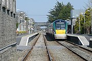 Athenry with a train heading to Galway
 -
 A steam hauled railtour in 1988
 -
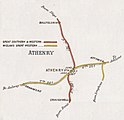 Athenry rail connections in the 1900s

.jpg)

See also
References
- ^ "Timetables". Irish Rail. Archived from the original on 2 April 2019. Retrieved 14 August 2012.
External links
This Ireland railway station-related article is a stub. You can help Wikipedia by expanding it. |
Categories:
- Wikipedia page with obscure subdivision
- Articles with short description
- Short description is different from Wikidata
- Use dmy dates from June 2020
- Use Hiberno-English from June 2020
- All Wikipedia articles written in Hiberno-English
- Articles containing Irish-language text
- Coordinates on Wikidata
- Articles using Infobox station with markup inside name
- Articles using Infobox station with links or images inside name
- 1851 establishments in Ireland
- Athenry
- Iarnród Éireann stations in County Galway
- Railway stations in County Galway
- Railway stations in the Republic of Ireland opened in 1851
- All stub articles
- Irish railway station stubs
- Pages using the Kartographer extension