Angiriai
Jump to navigation
Jump to search
Angiriai | |
|---|---|
Village | |
 | |
 Angiriai Location in Lithuania  Angiriai Angiriai (Lithuania) | |
| Coordinates: 55°16′59″N 23°45′00″E / 55.28306°N 23.75000°E | |
| Country | |
| County | |
| Municipality | Kėdainiai district municipality |
| Eldership | Josvainiai Eldership |
| Population (2011) | |
| • Total | 153 |
| Time zone | UTC+2 (EET) |
| • Summer (DST) | UTC+3 (EEST) |
Angiriai or Angeriai (meaning 'a place on woods', formerly Russian: Онгиры, Polish: Ongiry) is a village in Kėdainiai district municipality, in Kaunas County, in central Lithuania. According to the 2011 census, the village had a population of 153 people.[1] It is located 8 kilometres (5 mi) from Josvainiai, on the left bank of the Šušvė river, by the dam of the Angiriai Reservoir, near the Josvainiai Forest.
History
An ancient stone axe has been found in Angiriai.[2] At the beginning of the 20th century there was Angiriai manor and okolica.[3]
Demography
|
| |||||||||||||||||||||||||||||||||
| Source: 1902, 1923, 1959 & 1970, 1979, 1989, 2001, 2011 | ||||||||||||||||||||||||||||||||||
Images
-
 A blockhouse and memorial stone for the villages of Angiriai surroundings
 -
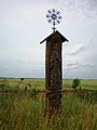 A roofed pole with the image of St. Mary near Angiriai


References
- ^ "2011 census". Statistikos Departamentas (Lithuania). Retrieved August 21, 2017.
- ^ "Angiriai". Tarybų Lietuvos enciklopedija (in Lithuanian). Vol. 1. Vilnius: Vyriausioji enciklopedijų redakcija. 1985. pp. 65–66.
- ^ "Ongiry". Geographical Dictionary of the Kingdom of Poland (in Polish). 15 pt. 2. Warszawa: Kasa im. Józefa Mianowskiego. 1902. p. 410.

Categories:
- Pages using gadget WikiMiniAtlas
- CS1 Lithuanian-language sources (lt)
- Articles with Polish-language sources (pl)
- Articles with short description
- Short description matches Wikidata
- Coordinates on Wikidata
- Articles containing Russian-language text
- Articles containing Polish-language text
- Villages in Kaunas County
- Kėdainiai District Municipality
- All stub articles
- Kaunas County geography stubs