Aguas Buenas barrio-pueblo
Aguas Buenas barrio-pueblo
Pueblo de Aguas Buenas | |
|---|---|
Municipality Seat[1] | |
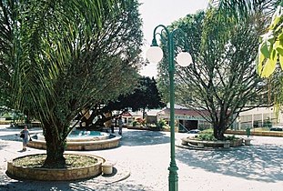
 The Central Plaza of Aguas Buenas in 2007 | |
 Location of Aguas Buenas barrio-pueblo within the municipality of Aguas Buenas shown in red | |
 Aguas Buenas barrio-pueblo Location of Puerto Rico | |
| Coordinates: 18°15′23″N 66°06′20″W / 18.256469°N 66.105428°W[2] | |
| Commonwealth | |
| Municipality | |
| Area | |
| • Total | 0.18 sq mi (0.5 km2) |
| • Land | 0.18 sq mi (0.5 km2) |
| • Water | 0.00 sq mi (0.0 km2) |
| Elevation | 850 ft (260 m) |
| Population (2010) | |
| • Total | 1,711 |
| • Density | 9,505.6/sq mi (3,670.1/km2) |
| Source: 2010 Census | |
| Time zone | UTC−4 (AST) |
Aguas Buenas barrio-pueblo is a barrio and the administrative center (seat) of Aguas Buenas, a municipality of Puerto Rico. Its population in 2010 was 1,711.[1][4][5]
As was customary in Spain, in Puerto Rico, the municipality has a barrio called pueblo which contains a central plaza, the municipal buildings (city hall), and a Catholic church. Fiestas patronales (patron saint festivals) are held in the central plaza every year.[6][7]
The central plaza and its church
The central plaza, or square, is a place for official and unofficial recreational events and a place where people can gather and socialize from dusk to dawn. The Laws of the Indies, Spanish law, which regulated life in Puerto Rico in the early 19th century, stated the plaza's purpose was for "the parties" (celebrations, festivities) (Spanish: a propósito para las fiestas), and that the square should be proportionally large enough for the number of neighbors (Spanish: grandeza proporcionada al número de vecinos). These Spanish regulations also stated that the streets nearby should be comfortable portals for passersby, protecting them from the elements: sun and rain.[6]
Located across from the central plaza in Aguas Buenas barrio-pueblo is the Parroquía Los Tres Santos Reyes, a Roman Catholic church. Other churches had been constructed in the area as early as 1834. A church made of cement was constructed in 1926 and provided services until it was demolished in 1968. The current church was designed by Gonzalo González Seijo and inaugurated in 1969.[8][9]
History
Aguas Buenas barrio-pueblo was in Spain's gazetteers[10] until Puerto Rico was ceded by Spain in the aftermath of the Spanish–American War under the terms of the Treaty of Paris of 1898 and became an unincorporated territory of the United States. In 1899, the United States Department of War conducted a census of Puerto Rico finding that the population of Pueblo was 1,309.[11]
| Census | Pop. | Note | %± |
|---|---|---|---|
| 1900 | 1,309 | — | |
| 1910 | 1,166 | −10.9% | |
| 1920 | 1,999 | 71.4% | |
| 1930 | 2,059 | 3.0% | |
| 1940 | 2,376 | 15.4% | |
| 1950 | 2,671 | 12.4% | |
| 1960 | 2,470 | −7.5% | |
| 1970 | 0 | −100.0% | |
| 1980 | 1,959 | — | |
| 1990 | 2,080 | 6.2% | |
| 2000 | 1,990 | −4.3% | |
| 2010 | 1,711 | −14.0% | |
| U.S. Decennial Census 1899 (shown as 1900)[12] 1910-1930[13] 1930-1950[14] 1980-2000[15] 2010[16] | |||
Gallery
Places in Aguas Buenas barrio-pueblo:
-
 Central Plaza
 -
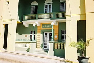 Town Hall (Casa Alcaldía)
 -
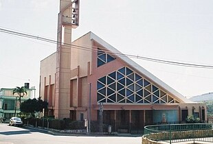 Los Tres Santos Reyes church


See also
References
- ^ a b Puerto Rico: 2010 Population and Housing Unit Counts.pdf (PDF). U.S. Dept. of Commerce, Economics and Statistics Administration, U.S. Census Bureau. 2010.
- ^ a b "US Gazetteer 2019". US Census. US Government.
- ^ U.S. Geological Survey Geographic Names Information System: Aguas Buenas barrio-pueblo
- ^ Picó, Rafael; Buitrago de Santiago, Zayda; Berrios, Hector H. Nueva geografía de Puerto Rico: física, económica, y social, por Rafael Picó. Con la colaboración de Zayda Buitrago de Santiago y Héctor H. Berrios. San Juan Editorial Universitaria, Universidad de Puerto Rico,1969.
- ^ Gwillim Law (20 May 2015). Administrative Subdivisions of Countries: A Comprehensive World Reference, 1900 through 1998. McFarland. p. 300. ISBN 978-1-4766-0447-3. Retrieved 25 December 2018.
- ^ a b Santullano, Luis A. (10 March 2019). Mirada al Caribe. Vol. 54. Colegio de Mexico. pp. 75–78. doi:10.2307/j.ctvbcd2vs.12. JSTOR j.ctvbcd2vs.12.
- ^ Pariser, Harry S. (2003). Explore Puerto Rico, Fifth Edition. San Francisco: Manatee Press. pp. 52–55. Retrieved 10 February 2019.
- ^ Mari Mut, José A. (2013-08-28). Los Pueblos de Puerto Rico y Las Iglesias de Sus Plazas [The Pueblos of Puerto Rico, and the Churches of its Plazas] (PDF) (in Spanish). pp. 4–6. Retrieved 2021-01-03.
- ^ "Iglesia Los Tres Santos Reyes". GCatholic (in Spanish). 2020-02-29. Retrieved 2021-01-03.
- ^ "Anuario del comercio, de la industria, de la magistratura y de la administración. 1881". Biblioteca Nacional de España (in Spanish). p. 1614. Retrieved 4 April 2023.
- ^ Joseph Prentiss Sanger; Henry Gannett; Walter Francis Willcox (1900). Informe sobre el censo de Puerto Rico, 1899, United States. War Dept. Porto Rico Census Office (in Spanish). Imprenta del gobierno. p. 162.
- ^ "Report of the Census of Porto Rico 1899". War Department Office Director Census of Porto Rico. Archived from the original on July 16, 2017. Retrieved September 21, 2017.
- ^ "Table 3-Population of Municipalities: 1930 1920 and 1910" (PDF). United States Census Bureau. Archived (PDF) from the original on August 17, 2017. Retrieved September 21, 2017.
- ^ "Table 4-Area and Population of Municipalities Urban and Rural: 1930 to 1950" (PDF). United States Census Bureau. Archived (PDF) from the original on August 30, 2015. Retrieved September 21, 2014.
- ^ "Table 2 Population and Housing Units: 1960 to 2000" (PDF). United States Census Bureau. Archived (PDF) from the original on July 24, 2017. Retrieved September 21, 2017.
- ^ Puerto Rico: 2010 Population and Housing Unit Counts.pdf (PDF). U.S. Dept. of Commerce Economics and Statistics Administration U.S. Census Bureau. 2010. Archived (PDF) from the original on 2017-02-20. Retrieved 2019-08-02.