Šarengrad
Šarengrad | |
|---|---|
 Šarengrad | |
 | |
 Šarengrad  Šarengrad  Šarengrad | |
| Coordinates: 45°13′52″N 19°16′48″E / 45.23111°N 19.28000°E | |
| Country | |
| County | |
| Municipality | Ilok |
| Area | |
| • Total | 33.3 km2 (12.9 sq mi) |
| Elevation | 92 m (302 ft) |
| Population (2021)[2] | |
| • Total | 362 |
| • Density | 11/km2 (28/sq mi) |
| Demonym(s) | Šarengrađanin (♂) Šarengrađanka (♀) (per grammatical gender) |
| Time zone | UTC+1 (CET) |
| • Summer (DST) | UTC+2 (CEST) |
| Postal code | 32234 Šarengrad |
| Area code | +385 0(32) |

Šarengrad (Serbian Cyrillic: Шаренград, Hungarian: Atya, German: Wetterwardein) is a village in eastern Croatia. It is located along the Danube river and is administratively part of Croatian easternmost town of Ilok. Šarengrad is known for its landscape which is dominated by the river and picturesque houses and church tower next to it. Island of Šarengrad is an 9 km2 river island situated close to the village.
Geography
The village is located in the Syrmia region, on the Fruška Gora slopes, next to the Danube river.
Demographics
| population | 1265 | 1484 | 1424 | 1558 | 1489 | 1472 | 1392 | 1448 | 1349 | 1622 | 1443 | 1357 | 1106 | 1005 | 838 | 528 | 362 |
| 1857 | 1869 | 1880 | 1890 | 1900 | 1910 | 1921 | 1931 | 1948 | 1953 | 1961 | 1971 | 1981 | 1991 | 2001 | 2011 | 2021 |
1991 census
| Šarengrad[3] |
|---|
| 1991 |
total: 1,005 Croats 904 (89.95%) Serbs 48 (4.77%) Slovaks 7 (0.69%) Yugoslavs 6 (0.59%) Hungarians 4 (0.39%) Muslims 3 (0.29%) Slovenes 2 (0.19%) Germans 1 (0.09%) Macedonians 1 (0.09%) Montenegrins 1 (0.09%) others 2 (0.19%) nondeclared 10 (0.99%) unknown 16 (1.59%)
|
1910 census
According to the 1910 census, settlement of Šarengrad had 1,472 inhabitants (in the main settlement Šarengrad 1,330 and in hamlets: Bjelica 47 and Šarengradska Dobra Voda 95), which were linguistically and religiously declared as this:
| Šarengrad[4] | |
|---|---|
| Population by language | Population by religion |
total: 1,472 Rom. Cath. 1,188 (80.70%) East. Orthodox 242 (16.44%) East. Catholics 20 (1.35%) Calvinists 12 (0.81%) Jewish 8 (0.54%) Lutherans 2 (0.13%)
| |
Gallery
-
 Main D2 road
 -

-
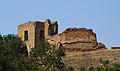 Medieval castle
 -
 Serbian orthodox church of the Transfiguration of the Lord
 -
 Yugoslav Partisans cemetery


.JPG)


See also
References
- ^ Register of spatial units of the State Geodetic Administration of the Republic of Croatia. Wikidata Q119585703.
- ^ "Population by Age and Sex, by Settlements, 2021 Census". Census of Population, Households and Dwellings in 2021. Zagreb: Croatian Bureau of Statistics. 2022.
- ^ Book: "Ethnic and religious composition of population of Croatia, 1880-1991: by settlements", author: Jakov Gelo, publisher: Zagreb, Croatian bureau of statistics, 1998., ISBN 953-6667-07-X, ISBN 978-953-6667-07-9;
- ^ Book: "Ethnic and religious composition of population of Croatia, 1880-1991: by settlements", author: Jakov Gelo, publisher: Zagreb, Croatian bureau of statistics, 1998., ISBN 953-6667-07-X, ISBN 978-953-6667-07-9;
External links
Villages of Vukovar-Syrmia County | ||
|---|---|---|
| Villages administered as part of cities |  | |
| Villages serving as municipal seat (other villages in municipality) | ||
| International | |
|---|---|
| National | |
This Vukovar-Syrmia County geography article is a stub. You can help Wikipedia by expanding it. |
- Articles with short description
- Short description is different from Wikidata
- Pages using infobox settlement with possible demonym list
- Articles containing Serbian-language text
- Articles containing Hungarian-language text
- Articles containing German-language text
- Commons category link from Wikidata
- Articles with VIAF identifiers
- Articles with J9U identifiers
- Articles with NKC identifiers
- Populated places on the Danube
- Populated places in Syrmia
- Populated places in Vukovar-Syrmia County
- Ilok
- All stub articles
- Vukovar-Srijem County geography stubs