Kruščić
Kruščić
| |
|---|---|
 Statue of Saint Florian | |
 Seal | |
 Map of Kruščić and other settlements in the neighborhood | |
 Kruščić  Kruščić  Kruščić | |
| Coordinates: 45°37′N 19°22′E / 45.617°N 19.367°E | |
| Country | |
| Province | |
| Region | Bačka |
| District | West Bačka |
| Municipality | Kula |
| Government | |
| • Village chief | Radisav Zejak |
| Population (2011) | |
| • Total | 1,852 |
| Time zone | UTC+1 (CET) |
| • Summer (DST) | UTC+2 (CEST) |
| Website | https://kruscicrs.tk/ |
Kruščić (Serbian Cyrillic: Крушчић, Hungarian: Veprőd) is a village in the Kula municipality, West Bačka District, Autonomous Province of Vojvodina, Republic of Serbia. The population of the village is ethnically mixed and numbers 1,852 people (2011 census).
Name
Before the Second World War, village was called Veprovac (Вепровац).
After the war, during the colonization, village was inhabited by colonists, mostly from Kolašin and its surroundings. In 1950 name of the village was changed to Kruščić, after national hero from World War II Vukman Kruščić (1909-1942), who was caught and killed on 20 January 1942, along with another 30 or so partisans, by the chetniks of Pavle Đurišić.
In Hungarian, the village is known as "Veprőd", in Ukrainian and Rusyn as "Крущич", and in German as "Weprovatz".
Ethnic groups
There are 1884 adult residents living in the village of Kruščić and the average age of residents is 40.5 years (38.4 for men and 42.7 for women). The village has 773 households and the average number of residents per household is 3.04.
The population in this village is very inhomogeneous, in the last three censuses a decline in population has been noticed.
According to the 2002 census, ethnic groups included:
- 768 (32.64%) Montenegrins
- 744 (31.62%) Serbs
- 280 (11.90%) Hungarians
- 149 (6.33%) Ukrainians
- 99 (4.20%) Rusyns
- 74 (3.14%) Croatians
- 45 (1,91%) Yugoslavs
- 10 (0,42%) Germans
- 8 (0.33%) Macedonians
- 5 (0.21%) Slovaks
- 4 (0.16%) Slovenes
- 2 (0.08%) Bulgarians
- 2 (0.08%) Albanians
- 1 (0.04%) Russians
- 1 (0.04%) Romanians
- 1 (0.04%) Bunjevci
- 1 (0.04%) Bosniaks
- 22 (0.93%) Unknown
Historical population
- 1787: 1,731 (55% Hungarians and Slovaks, 45% Germans)
- 1910: 3,163 (2,458 Germans, 637 Hungarians, 53 Rusyns)
- 1931: 3,158 (2,551 Germans, 489 Hungarians, 118 Slavs)
- 1961: 3,281
- 1971: 2,927
- 1981: 2,658
- 1991: 2,477 (973 Montenegrins, 539 Serbs, 350 Hungarians, 18 Germans)
- 2002: 2,353 (768 Montenegrins, 744 Serbs, 280 Hungarians, 10 Germans)
Gallery
-
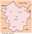 Map of Kula municipality showing the location of the village
 -
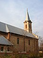 Saint Stephen the King Catholic Church


See also
References
- Slobodan Ćurčić, Broj stanovnika Vojvodine, Novi Sad, 1996.
External links
Cities, towns and villages in the West Bačka District | ||
|---|---|---|
| Sombor |  | |
| Apatin | ||
| Kula | ||
| Odžaci | ||
bold are municipalities or cities | ||
| International | |
|---|---|
| National | |
45°37′N 19°22′E / 45.617°N 19.367°E
This West Bačka District, Vojvodina location article is a stub. You can help Wikipedia by expanding it. |
- Articles with short description
- Short description is different from Wikidata
- Articles containing Serbian-language text
- Articles containing Hungarian-language text
- Commons category link is on Wikidata
- All articles with dead external links
- Articles with dead external links from December 2017
- Articles with permanently dead external links
- Articles with VIAF identifiers
- Articles with J9U identifiers
- Articles with LCCN identifiers
- Coordinates on Wikidata
- Places in Bačka
- Populated places in West Bačka District
- Kula, Serbia
- Montenegrin communities
- All stub articles
- Vojvodina geography stubs